You are here: Home > Network List > TA - USArray Transportable Network (new EarthScope stations) Stations List
> Station K08A Mann Creek Ranch, Princeton, OR, USA > Earthquake Result Viewer
K08A Mann Creek Ranch, Princeton, OR, USA - Earthquake Result Viewer
| Earthquake location: |
Mariana Islands |
| Earthquake latitude/longitude: |
18.9/145.4 |
| Earthquake time(UTC): |
2007/10/31 (304) 03:30:17 GMT |
| Earthquake Depth: |
223 km |
| Earthquake Magnitude: |
6.2 MB, 7.2 MW, 7.2 MW |
| Earthquake Catalog/Contributor: |
WHDF/NEIC |
|
| Network: |
TA USArray Transportable Network (new EarthScope stations) |
| Station: |
K08A Mann Creek Ranch, Princeton, OR, USA |
| Lat/Lon: |
42.73 N/118.49 W |
| Elevation: |
1391 m |
|
| Distance: |
81.8 deg |
| Az: |
47.746 deg |
| Baz: |
287.995 deg |
| Ray Param: |
0.046787865 |
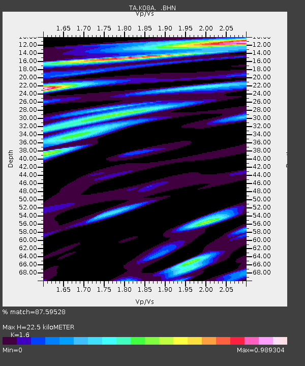
| Estimated Moho Depth: |
22.5 km |
| Estimated Crust Vp/Vs: |
1.60 |
| Assumed Crust Vp: |
6.279 km/s |
| Estimated Crust Vs: |
3.924 km/s |
| Estimated Crust Poisson's Ratio: |
0.18 |
|
| Radial Match: |
87.59528 % |
| Radial Bump: |
400 |
| Transverse Match: |
74.642685 % |
| Transverse Bump: |
400 |
| SOD ConfigId: |
2564 |
| Insert Time: |
2010-03-07 01:31:03.391 +0000 |
| GWidth: |
2.5 |
| Max Bumps: |
400 |
| Tol: |
0.001 |
|
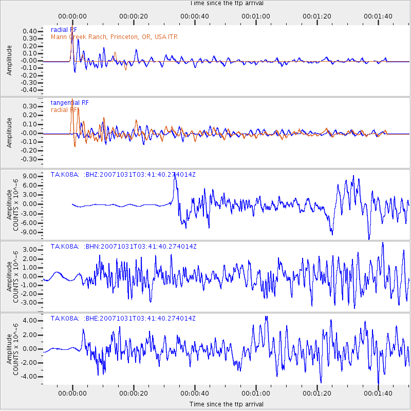
Signal To Noise
| Channel | StoN | STA | LTA |
| TA:K08A: :BHN:20071031T03:41:40.274014Z | 1.9133868 | 3.7506916E-7 | 1.960237E-7 |
| TA:K08A: :BHE:20071031T03:41:40.274014Z | 3.793945 | 9.584261E-7 | 2.526199E-7 |
| TA:K08A: :BHZ:20071031T03:41:40.274014Z | 15.970848 | 3.8926028E-6 | 2.4373173E-7 |
| Arrivals |
| Ps | 2.2 SECOND |
| PpPs | 9.1 SECOND |
| PsPs/PpSs | 11 SECOND |


