You are here: Home > Network List > TA - USArray Transportable Network (new EarthScope stations) Stations List
> Station K08A Mann Creek Ranch, Princeton, OR, USA > Earthquake Result Viewer
K08A Mann Creek Ranch, Princeton, OR, USA - Earthquake Result Viewer
| Earthquake location: |
Volcano Islands, Japan Region |
| Earthquake latitude/longitude: |
22.0/142.7 |
| Earthquake time(UTC): |
2007/09/28 (271) 13:38:59 GMT |
| Earthquake Depth: |
276 km |
| Earthquake Magnitude: |
6.7 MB, 7.4 MW, 7.4 MW |
| Earthquake Catalog/Contributor: |
WHDF/NEIC |
|
| Network: |
TA USArray Transportable Network (new EarthScope stations) |
| Station: |
K08A Mann Creek Ranch, Princeton, OR, USA |
| Lat/Lon: |
42.73 N/118.49 W |
| Elevation: |
1391 m |
|
| Distance: |
81.6 deg |
| Az: |
47.388 deg |
| Baz: |
292.036 deg |
| Ray Param: |
0.04677793 |
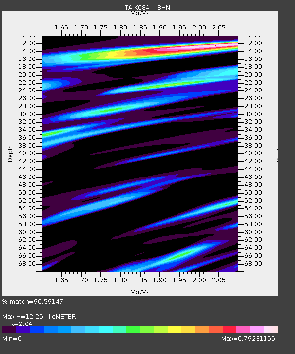
| Estimated Moho Depth: |
12.25 km |
| Estimated Crust Vp/Vs: |
2.04 |
| Assumed Crust Vp: |
6.279 km/s |
| Estimated Crust Vs: |
3.078 km/s |
| Estimated Crust Poisson's Ratio: |
0.34 |
|
| Radial Match: |
90.59147 % |
| Radial Bump: |
400 |
| Transverse Match: |
75.23534 % |
| Transverse Bump: |
400 |
| SOD ConfigId: |
2564 |
| Insert Time: |
2010-03-07 01:31:10.221 +0000 |
| GWidth: |
2.5 |
| Max Bumps: |
400 |
| Tol: |
0.001 |
|
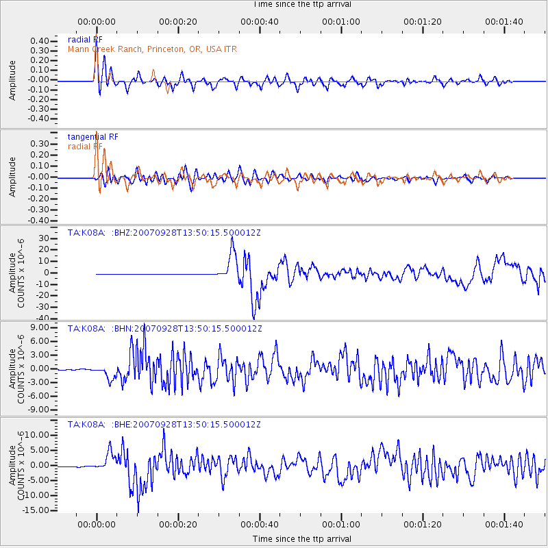
Signal To Noise
| Channel | StoN | STA | LTA |
| TA:K08A: :BHN:20070928T13:50:15.500012Z | 13.743395 | 1.5194454E-6 | 1.1055823E-7 |
| TA:K08A: :BHE:20070928T13:50:15.500012Z | 38.156124 | 3.2617434E-6 | 8.548413E-8 |
| TA:K08A: :BHZ:20070928T13:50:15.500012Z | 100.93131 | 1.3062507E-5 | 1.2941977E-7 |
| Arrivals |
| Ps | 2.1 SECOND |
| PpPs | 5.8 SECOND |
| PsPs/PpSs | 7.9 SECOND |


