You are here: Home > Network List > TA - USArray Transportable Network (new EarthScope stations) Stations List
> Station K08A Mann Creek Ranch, Princeton, OR, USA > Earthquake Result Viewer
K08A Mann Creek Ranch, Princeton, OR, USA - Earthquake Result Viewer
| Earthquake location: |
South Of Fiji Islands |
| Earthquake latitude/longitude: |
-26.0/-177.5 |
| Earthquake time(UTC): |
2007/12/09 (343) 07:28:20 GMT |
| Earthquake Depth: |
152 km |
| Earthquake Magnitude: |
7.0 MB, 7.8 MW, 7.7 MW |
| Earthquake Catalog/Contributor: |
WHDF/NEIC |
|
| Network: |
TA USArray Transportable Network (new EarthScope stations) |
| Station: |
K08A Mann Creek Ranch, Princeton, OR, USA |
| Lat/Lon: |
42.73 N/118.49 W |
| Elevation: |
1391 m |
|
| Distance: |
87.3 deg |
| Az: |
39.231 deg |
| Baz: |
230.578 deg |
| Ray Param: |
0.04306094 |
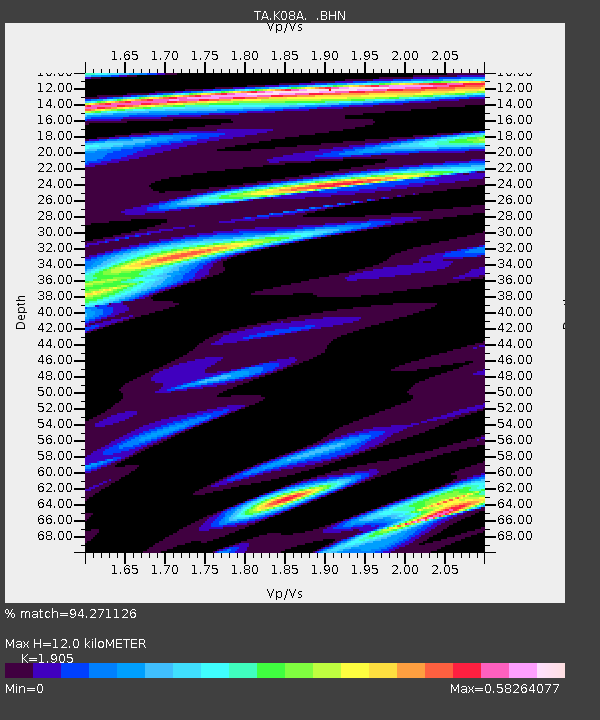
| Estimated Moho Depth: |
12.0 km |
| Estimated Crust Vp/Vs: |
1.90 |
| Assumed Crust Vp: |
6.279 km/s |
| Estimated Crust Vs: |
3.296 km/s |
| Estimated Crust Poisson's Ratio: |
0.31 |
|
| Radial Match: |
94.271126 % |
| Radial Bump: |
361 |
| Transverse Match: |
90.45797 % |
| Transverse Bump: |
400 |
| SOD ConfigId: |
2564 |
| Insert Time: |
2010-03-07 01:31:18.016 +0000 |
| GWidth: |
2.5 |
| Max Bumps: |
400 |
| Tol: |
0.001 |
|

Signal To Noise
| Channel | StoN | STA | LTA |
| TA:K08A: :BHN:20071209T07:40:19.275017Z | 0.9675624 | 2.820513E-7 | 2.915071E-7 |
| TA:K08A: :BHE:20071209T07:40:19.275017Z | 3.608184 | 7.8479815E-7 | 2.1750502E-7 |
| TA:K08A: :BHZ:20071209T07:40:19.275017Z | 6.1749673 | 1.2932846E-6 | 2.0943992E-7 |
| Arrivals |
| Ps | 1.8 SECOND |
| PpPs | 5.4 SECOND |
| PsPs/PpSs | 7.2 SECOND |


