You are here: Home > Network List > TA - USArray Transportable Network (new EarthScope stations) Stations List
> Station B18K Kokolik River, AK, USA > Earthquake Result Viewer
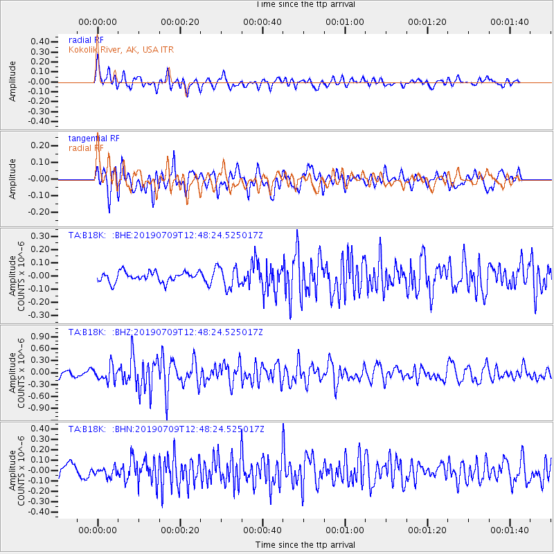
B18K Kokolik River, AK, USA - Earthquake Result Viewer
*The percent match for this event was below the threshold and hence no stack was calculated.
| Earthquake location: |
Mindanao, Philippines |
| Earthquake latitude/longitude: |
6.8/125.2 |
| Earthquake time(UTC): |
2019/07/09 (190) 12:37:01 GMT |
| Earthquake Depth: |
24 km |
| Earthquake Magnitude: |
5.6 Mww |
| Earthquake Catalog/Contributor: |
NEIC PDE/us |
|
| Network: |
TA USArray Transportable Network (new EarthScope stations) |
| Station: |
B18K Kokolik River, AK, USA |
| Lat/Lon: |
69.36 N/161.80 W |
| Elevation: |
222 m |
|
| Distance: |
77.7 deg |
| Az: |
20.305 deg |
| Baz: |
256.427 deg |
| Ray Param: |
$rayparam |
*The percent match for this event was below the threshold and hence was not used in the summary stack. |
|
| Radial Match: |
75.57077 % |
| Radial Bump: |
400 |
| Transverse Match: |
72.88508 % |
| Transverse Bump: |
400 |
| SOD ConfigId: |
19053131 |
| Insert Time: |
2019-07-23 12:40:20.971 +0000 |
| GWidth: |
2.5 |
| Max Bumps: |
400 |
| Tol: |
0.001 |
|
Signal To Noise
| Channel | StoN | STA | LTA |
| TA:B18K: :BHZ:20190709T12:48:24.525017Z | 2.8121333 | 1.8669704E-7 | 6.638982E-8 |
| TA:B18K: :BHN:20190709T12:48:24.525017Z | 0.843508 | 4.5135383E-8 | 5.3509133E-8 |
| TA:B18K: :BHE:20190709T12:48:24.525017Z | 2.1037452 | 7.8254324E-8 | 3.7197626E-8 |
| Arrivals |
| Ps | |
| PpPs | |
| PsPs/PpSs | |


