You are here: Home > Network List > TA - USArray Transportable Network (new EarthScope stations) Stations List
> Station D27M Malcolm River, YT, CAN > Earthquake Result Viewer
D27M Malcolm River, YT, CAN - Earthquake Result Viewer
| Earthquake location: |
Mindanao, Philippines |
| Earthquake latitude/longitude: |
6.8/125.2 |
| Earthquake time(UTC): |
2019/07/09 (190) 12:37:01 GMT |
| Earthquake Depth: |
24 km |
| Earthquake Magnitude: |
5.6 Mww |
| Earthquake Catalog/Contributor: |
NEIC PDE/us |
|
| Network: |
TA USArray Transportable Network (new EarthScope stations) |
| Station: |
D27M Malcolm River, YT, CAN |
| Lat/Lon: |
69.24 N/140.96 W |
| Elevation: |
896 m |
|
| Distance: |
85.1 deg |
| Az: |
20.916 deg |
| Baz: |
276.021 deg |
| Ray Param: |
0.045007743 |
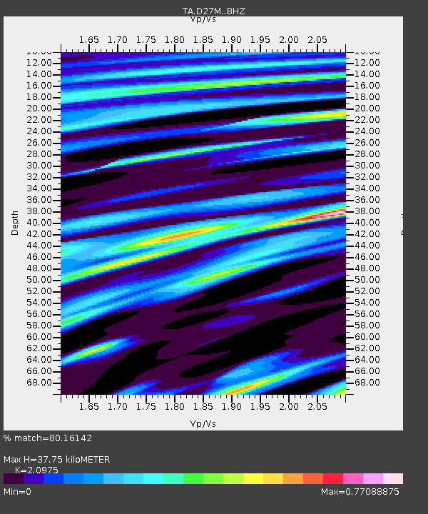
| Estimated Moho Depth: |
37.75 km |
| Estimated Crust Vp/Vs: |
2.10 |
| Assumed Crust Vp: |
6.522 km/s |
| Estimated Crust Vs: |
3.109 km/s |
| Estimated Crust Poisson's Ratio: |
0.35 |
|
| Radial Match: |
80.16142 % |
| Radial Bump: |
400 |
| Transverse Match: |
76.94086 % |
| Transverse Bump: |
400 |
| SOD ConfigId: |
19053131 |
| Insert Time: |
2019-07-23 12:40:31.464 +0000 |
| GWidth: |
2.5 |
| Max Bumps: |
400 |
| Tol: |
0.001 |
|

Signal To Noise
| Channel | StoN | STA | LTA |
| TA:D27M: :BHZ:20190709T12:49:03.29998Z | 2.9712017 | 1.5099965E-7 | 5.082107E-8 |
| TA:D27M: :BHN:20190709T12:49:03.29998Z | 1.0752393 | 4.3993563E-8 | 4.0915133E-8 |
| TA:D27M: :BHE:20190709T12:49:03.29998Z | 1.3866774 | 5.3336727E-8 | 3.8463686E-8 |
| Arrivals |
| Ps | 6.5 SECOND |
| PpPs | 18 SECOND |
| PsPs/PpSs | 24 SECOND |


