You are here: Home > Network List > TA - USArray Transportable Network (new EarthScope stations) Stations List
> Station K08A Mann Creek Ranch, Princeton, OR, USA > Earthquake Result Viewer
K08A Mann Creek Ranch, Princeton, OR, USA - Earthquake Result Viewer
| Earthquake location: |
Near West Coast Of Honshu, Japan |
| Earthquake latitude/longitude: |
37.5/138.4 |
| Earthquake time(UTC): |
2007/07/16 (197) 01:13:22 GMT |
| Earthquake Depth: |
12 km |
| Earthquake Magnitude: |
6.5 MB, 6.4 MS, 6.6 MW, 6.5 MW |
| Earthquake Catalog/Contributor: |
WHDF/NEIC |
|
| Network: |
TA USArray Transportable Network (new EarthScope stations) |
| Station: |
K08A Mann Creek Ranch, Princeton, OR, USA |
| Lat/Lon: |
42.73 N/118.49 W |
| Elevation: |
1391 m |
|
| Distance: |
73.9 deg |
| Az: |
48.342 deg |
| Baz: |
306.285 deg |
| Ray Param: |
0.05270801 |
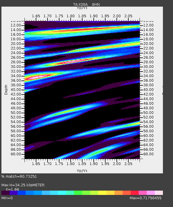
| Estimated Moho Depth: |
34.25 km |
| Estimated Crust Vp/Vs: |
1.66 |
| Assumed Crust Vp: |
6.279 km/s |
| Estimated Crust Vs: |
3.782 km/s |
| Estimated Crust Poisson's Ratio: |
0.22 |
|
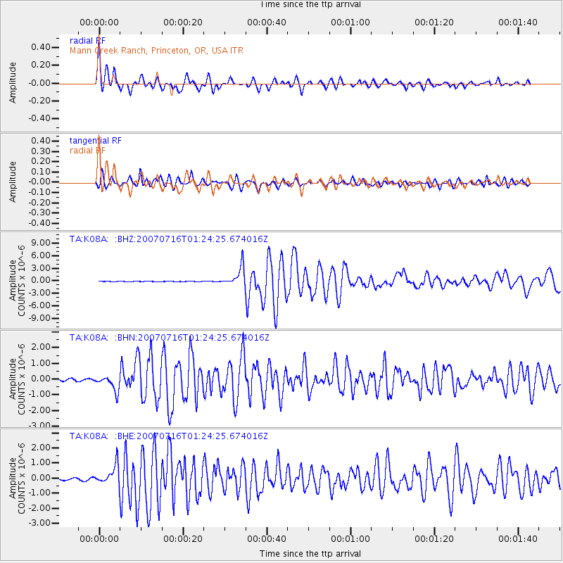
| Radial Match: |
90.73251 % |
| Radial Bump: |
400 |
| Transverse Match: |
90.42945 % |
| Transverse Bump: |
400 |
| SOD ConfigId: |
2564 |
| Insert Time: |
2010-03-07 01:31:55.399 +0000 |
| GWidth: |
2.5 |
| Max Bumps: |
400 |
| Tol: |
0.001 |
|
Signal To Noise
| Channel | StoN | STA | LTA |
| TA:K08A: :BHN:20070716T01:24:25.674016Z | 7.69636 | 5.030346E-7 | 6.536006E-8 |
| TA:K08A: :BHE:20070716T01:24:25.674016Z | 12.328354 | 6.6110636E-7 | 5.362487E-8 |
| TA:K08A: :BHZ:20070716T01:24:25.674016Z | 43.066105 | 2.3352172E-6 | 5.422402E-8 |
| Arrivals |
| Ps | 3.7 SECOND |
| PpPs | 14 SECOND |
| PsPs/PpSs | 18 SECOND |


