You are here: Home > Network List > TA - USArray Transportable Network (new EarthScope stations) Stations List
> Station K08A Mann Creek Ranch, Princeton, OR, USA > Earthquake Result Viewer
K08A Mann Creek Ranch, Princeton, OR, USA - Earthquake Result Viewer
| Earthquake location: |
Solomon Islands |
| Earthquake latitude/longitude: |
-8.5/157.0 |
| Earthquake time(UTC): |
2007/04/01 (091) 20:39:56 GMT |
| Earthquake Depth: |
10 km |
| Earthquake Magnitude: |
6.8 MB, 7.9 MS, 8.1 MW, 7.7 ME |
| Earthquake Catalog/Contributor: |
WHDF/NEIC |
|
| Network: |
TA USArray Transportable Network (new EarthScope stations) |
| Station: |
K08A Mann Creek Ranch, Princeton, OR, USA |
| Lat/Lon: |
42.73 N/118.49 W |
| Elevation: |
1391 m |
|
| Distance: |
91.6 deg |
| Az: |
47.196 deg |
| Baz: |
260.083 deg |
| Ray Param: |
0.04157959 |
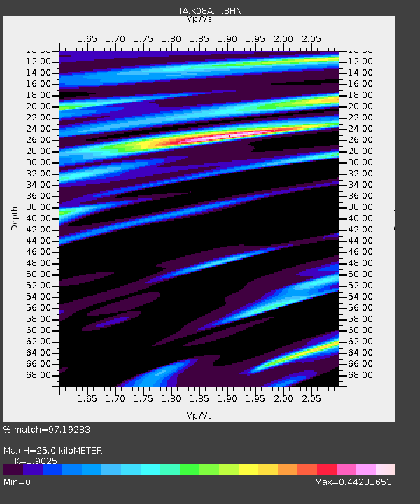
| Estimated Moho Depth: |
25.0 km |
| Estimated Crust Vp/Vs: |
1.90 |
| Assumed Crust Vp: |
6.279 km/s |
| Estimated Crust Vs: |
3.3 km/s |
| Estimated Crust Poisson's Ratio: |
0.31 |
|
| Radial Match: |
97.19283 % |
| Radial Bump: |
400 |
| Transverse Match: |
85.49933 % |
| Transverse Bump: |
400 |
| SOD ConfigId: |
2564 |
| Insert Time: |
2010-03-07 01:32:17.934 +0000 |
| GWidth: |
2.5 |
| Max Bumps: |
400 |
| Tol: |
0.001 |
|

Signal To Noise
| Channel | StoN | STA | LTA |
| TA:K08A: :BHN:20070401T20:52:31.973018Z | 1.2789385 | 1.6996266E-7 | 1.3289355E-7 |
| TA:K08A: :BHE:20070401T20:52:31.973018Z | 3.886038 | 3.5032016E-7 | 9.014841E-8 |
| TA:K08A: :BHZ:20070401T20:52:31.973018Z | 10.809198 | 1.3639547E-6 | 1.2618463E-7 |
| Arrivals |
| Ps | 3.7 SECOND |
| PpPs | 11 SECOND |
| PsPs/PpSs | 15 SECOND |


