You are here: Home > Network List > TA - USArray Transportable Network (new EarthScope stations) Stations List
> Station K08A Mann Creek Ranch, Princeton, OR, USA > Earthquake Result Viewer
K08A Mann Creek Ranch, Princeton, OR, USA - Earthquake Result Viewer

| Earthquake location: |
Solomon Islands |
| Earthquake latitude/longitude: |
-6.8/155.5 |
| Earthquake time(UTC): |
2006/09/01 (244) 10:18:51 GMT |
| Earthquake Depth: |
38 km |
| Earthquake Magnitude: |
6.3 MB, 6.7 MS, 6.8 MW, 6.7 MW |
| Earthquake Catalog/Contributor: |
WHDF/NEIC |
|
| Network: |
TA USArray Transportable Network (new EarthScope stations) |
| Station: |
K08A Mann Creek Ranch, Princeton, OR, USA |
| Lat/Lon: |
42.73 N/118.49 W |
| Elevation: |
1391 m |
|
| Distance: |
91.6 deg |
| Az: |
47.334 deg |
| Baz: |
262.356 deg |
| Ray Param: |
0.041573666 |
| Estimated Moho Depth: |
24.75 km |
| Estimated Crust Vp/Vs: |
1.89 |
| Assumed Crust Vp: |
6.279 km/s |
| Estimated Crust Vs: |
3.322 km/s |
| Estimated Crust Poisson's Ratio: |
0.31 |
|
| Radial Match: |
83.92093 % |
| Radial Bump: |
400 |
| Transverse Match: |
74.07552 % |
| Transverse Bump: |
400 |
| SOD ConfigId: |
2665 |
| Insert Time: |
2010-03-07 01:32:38.879 +0000 |
| GWidth: |
2.5 |
| Max Bumps: |
400 |
| Tol: |
0.001 |
|
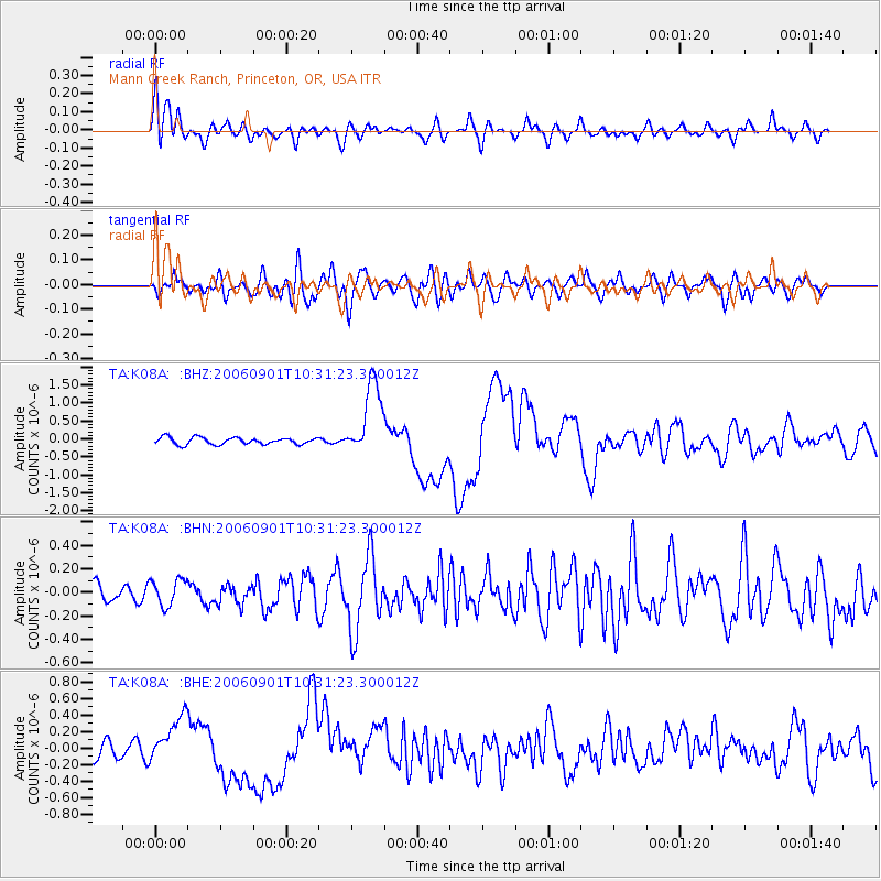
Signal To Noise
| Channel | StoN | STA | LTA |
| TA:K08A: :BHN:20060901T10:31:23.300012Z | 1.4501035 | 1.1318937E-7 | 7.805606E-8 |
| TA:K08A: :BHE:20060901T10:31:23.300012Z | 2.6603665 | 2.8759095E-7 | 1.0810201E-7 |
| TA:K08A: :BHZ:20060901T10:31:23.300012Z | 10.772387 | 1.0502486E-6 | 9.749451E-8 |
| Arrivals |
| Ps | 3.6 SECOND |
| PpPs | 11 SECOND |
| PsPs/PpSs | 15 SECOND |


