You are here: Home > Network List > US - United States National Seismic Network Stations List
> Station DGMT Dagmar, Montana, USA > Earthquake Result Viewer
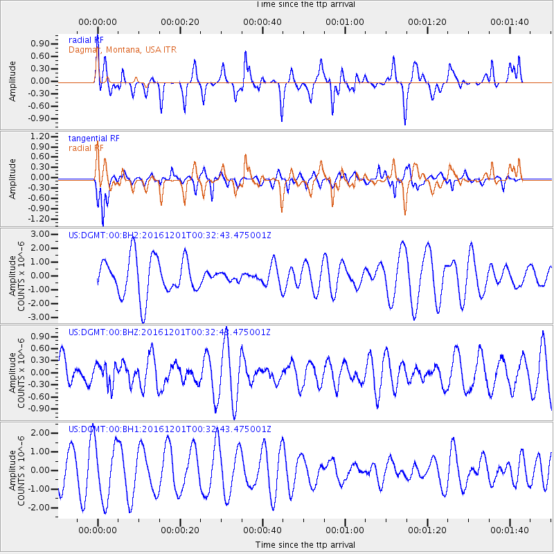
DGMT Dagmar, Montana, USA - Earthquake Result Viewer
*The percent match for this event was below the threshold and hence no stack was calculated.
| Earthquake location: |
Costa Rica |
| Earthquake latitude/longitude: |
9.9/-83.8 |
| Earthquake time(UTC): |
2016/12/01 (336) 00:25:21 GMT |
| Earthquake Depth: |
1.3 km |
| Earthquake Magnitude: |
5.3 Mww |
| Earthquake Catalog/Contributor: |
NEIC PDE/us |
|
| Network: |
US United States National Seismic Network |
| Station: |
DGMT Dagmar, Montana, USA |
| Lat/Lon: |
48.47 N/104.20 W |
| Elevation: |
0.0 m |
|
| Distance: |
42.0 deg |
| Az: |
339.744 deg |
| Baz: |
149.169 deg |
| Ray Param: |
$rayparam |
*The percent match for this event was below the threshold and hence was not used in the summary stack. |
|
| Radial Match: |
70.60634 % |
| Radial Bump: |
400 |
| Transverse Match: |
68.88045 % |
| Transverse Bump: |
394 |
| SOD ConfigId: |
1894071 |
| Insert Time: |
2016-12-30 04:02:34.324 +0000 |
| GWidth: |
2.5 |
| Max Bumps: |
400 |
| Tol: |
0.001 |
|
Signal To Noise
| Channel | StoN | STA | LTA |
| US:DGMT:00:BHZ:20161201T00:32:43.475001Z | 0.4716368 | 2.6327564E-7 | 5.5821687E-7 |
| US:DGMT:00:BH1:20161201T00:32:43.475001Z | 2.1307116 | 1.5330279E-6 | 7.19491E-7 |
| US:DGMT:00:BH2:20161201T00:32:43.475001Z | 0.19161606 | 2.5981387E-7 | 1.3559086E-6 |
| Arrivals |
| Ps | |
| PpPs | |
| PsPs/PpSs | |


