You are here: Home > Network List > TA - USArray Transportable Network (new EarthScope stations) Stations List
> Station F21K Alatna River, AK, USA > Earthquake Result Viewer
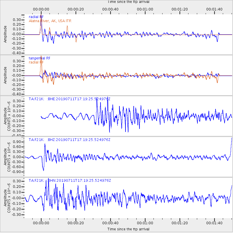
F21K Alatna River, AK, USA - Earthquake Result Viewer
*The percent match for this event was below the threshold and hence no stack was calculated.
| Earthquake location: |
Solomon Islands |
| Earthquake latitude/longitude: |
-4.7/155.2 |
| Earthquake time(UTC): |
2019/07/11 (192) 17:08:37 GMT |
| Earthquake Depth: |
496 km |
| Earthquake Magnitude: |
6.0 Mww |
| Earthquake Catalog/Contributor: |
NEIC PDE/us |
|
| Network: |
TA USArray Transportable Network (new EarthScope stations) |
| Station: |
F21K Alatna River, AK, USA |
| Lat/Lon: |
67.22 N/153.48 W |
| Elevation: |
597 m |
|
| Distance: |
80.3 deg |
| Az: |
17.949 deg |
| Baz: |
232.079 deg |
| Ray Param: |
$rayparam |
*The percent match for this event was below the threshold and hence was not used in the summary stack. |
|
| Radial Match: |
70.98645 % |
| Radial Bump: |
400 |
| Transverse Match: |
52.729324 % |
| Transverse Bump: |
400 |
| SOD ConfigId: |
19053131 |
| Insert Time: |
2019-07-25 17:15:25.977 +0000 |
| GWidth: |
2.5 |
| Max Bumps: |
400 |
| Tol: |
0.001 |
|
Signal To Noise
| Channel | StoN | STA | LTA |
| TA:F21K: :BHZ:20190711T17:19:25.524976Z | 6.2994356 | 3.8584432E-7 | 6.125062E-8 |
| TA:F21K: :BHN:20190711T17:19:25.524976Z | 3.7509615 | 1.3699832E-7 | 3.652352E-8 |
| TA:F21K: :BHE:20190711T17:19:25.524976Z | 3.490235 | 1.3377831E-7 | 3.8329315E-8 |
| Arrivals |
| Ps | |
| PpPs | |
| PsPs/PpSs | |


