You are here: Home > Network List > TA - USArray Transportable Network (new EarthScope stations) Stations List
> Station G26K Porcupine River, AK, USA > Earthquake Result Viewer
G26K Porcupine River, AK, USA - Earthquake Result Viewer
| Earthquake location: |
Solomon Islands |
| Earthquake latitude/longitude: |
-4.7/155.2 |
| Earthquake time(UTC): |
2019/07/11 (192) 17:08:37 GMT |
| Earthquake Depth: |
496 km |
| Earthquake Magnitude: |
6.0 Mww |
| Earthquake Catalog/Contributor: |
NEIC PDE/us |
|
| Network: |
TA USArray Transportable Network (new EarthScope stations) |
| Station: |
G26K Porcupine River, AK, USA |
| Lat/Lon: |
66.95 N/143.78 W |
| Elevation: |
180 m |
|
| Distance: |
83.3 deg |
| Az: |
20.283 deg |
| Baz: |
241.339 deg |
| Ray Param: |
0.04485859 |
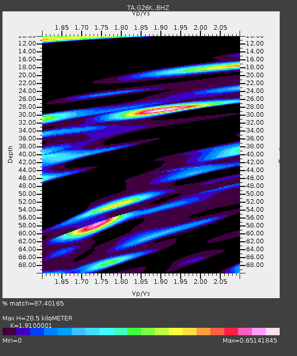
| Estimated Moho Depth: |
28.5 km |
| Estimated Crust Vp/Vs: |
1.91 |
| Assumed Crust Vp: |
6.577 km/s |
| Estimated Crust Vs: |
3.443 km/s |
| Estimated Crust Poisson's Ratio: |
0.31 |
|
| Radial Match: |
87.40165 % |
| Radial Bump: |
333 |
| Transverse Match: |
77.85535 % |
| Transverse Bump: |
400 |
| SOD ConfigId: |
19053131 |
| Insert Time: |
2019-07-25 17:15:34.951 +0000 |
| GWidth: |
2.5 |
| Max Bumps: |
400 |
| Tol: |
0.001 |
|

Signal To Noise
| Channel | StoN | STA | LTA |
| TA:G26K: :BHZ:20190711T17:19:40.899976Z | 16.599478 | 9.368477E-7 | 5.6438385E-8 |
| TA:G26K: :BHN:20190711T17:19:40.899976Z | 4.1115227 | 3.2398853E-7 | 7.8800134E-8 |
| TA:G26K: :BHE:20190711T17:19:40.899976Z | 6.748143 | 3.264661E-7 | 4.8378656E-8 |
| Arrivals |
| Ps | 4.0 SECOND |
| PpPs | 12 SECOND |
| PsPs/PpSs | 16 SECOND |


