You are here: Home > Network List > G - GEOSCOPE Stations List
> Station DRV Dumont d'Urville, Terre Adelie (Antartica) > Earthquake Result Viewer
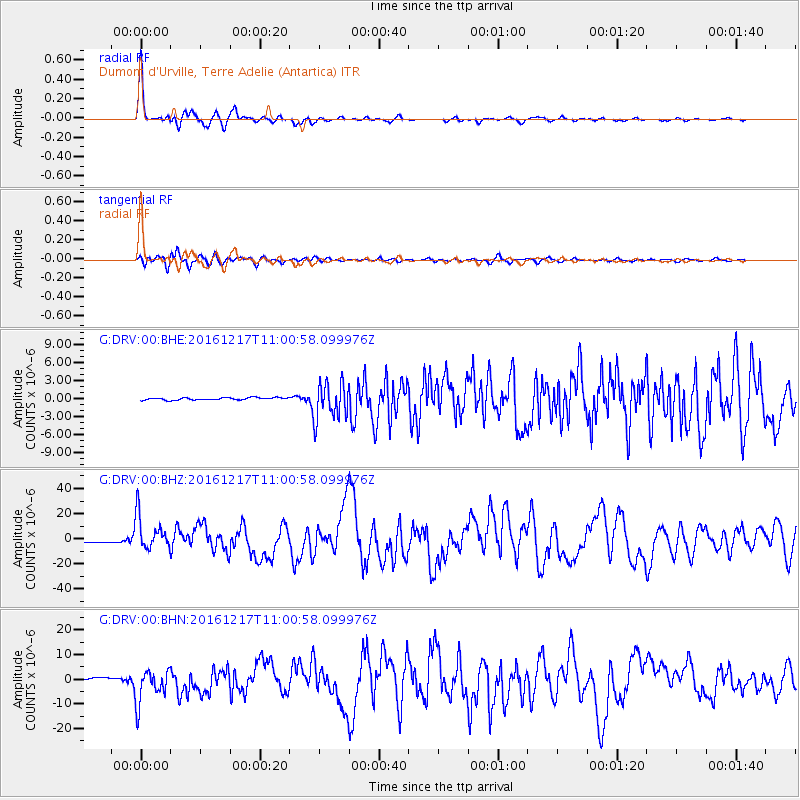
DRV Dumont d'Urville, Terre Adelie (Antartica) - Earthquake Result Viewer
| Earthquake location: |
New Ireland Region, P.N.G. |
| Earthquake latitude/longitude: |
-4.5/153.6 |
| Earthquake time(UTC): |
2016/12/17 (352) 10:51:11 GMT |
| Earthquake Depth: |
73 km |
| Earthquake Magnitude: |
8.0 Mi |
| Earthquake Catalog/Contributor: |
NEIC PDE/pt |
|
| Network: |
G GEOSCOPE |
| Station: |
DRV Dumont d'Urville, Terre Adelie (Antartica) |
| Lat/Lon: |
66.67 S/140.01 E |
| Elevation: |
40 m |
|
| Distance: |
62.8 deg |
| Az: |
186.031 deg |
| Baz: |
15.246 deg |
| Ray Param: |
0.05980823 |
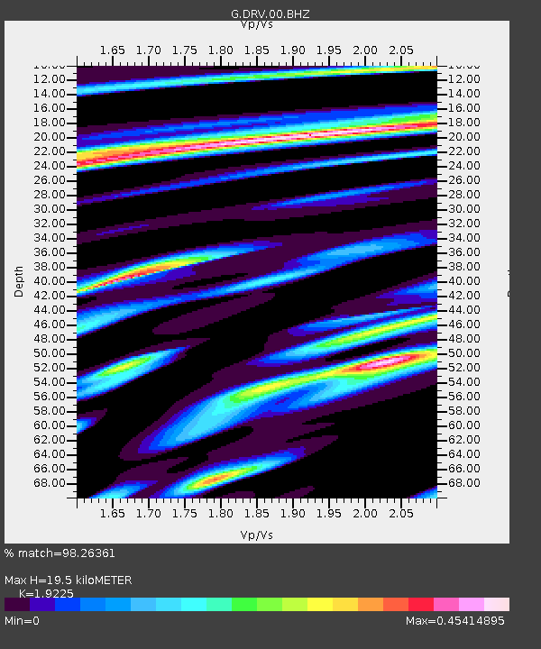
| Estimated Moho Depth: |
19.5 km |
| Estimated Crust Vp/Vs: |
1.92 |
| Assumed Crust Vp: |
6.39 km/s |
| Estimated Crust Vs: |
3.324 km/s |
| Estimated Crust Poisson's Ratio: |
0.31 |
|
| Radial Match: |
98.26361 % |
| Radial Bump: |
308 |
| Transverse Match: |
94.95341 % |
| Transverse Bump: |
400 |
| SOD ConfigId: |
1894071 |
| Insert Time: |
2016-12-31 10:52:16.707 +0000 |
| GWidth: |
2.5 |
| Max Bumps: |
400 |
| Tol: |
0.001 |
|
Signal To Noise
| Channel | StoN | STA | LTA |
| G:DRV:00:BHZ:20161217T11:00:58.099976Z | 15.9135065 | 1.3724665E-5 | 8.624539E-7 |
| G:DRV:00:BHN:20161217T11:00:58.099976Z | 12.206938 | 6.878736E-6 | 5.6351035E-7 |
| G:DRV:00:BHE:20161217T11:00:58.099976Z | 15.783043 | 3.0774252E-6 | 1.94983E-7 |
| Arrivals |
| Ps | 2.9 SECOND |
| PpPs | 8.6 SECOND |
| PsPs/PpSs | 11 SECOND |


