You are here: Home > Network List > TA - USArray Transportable Network (new EarthScope stations) Stations List
> Station G31M Satah River, YT, CAN > Earthquake Result Viewer
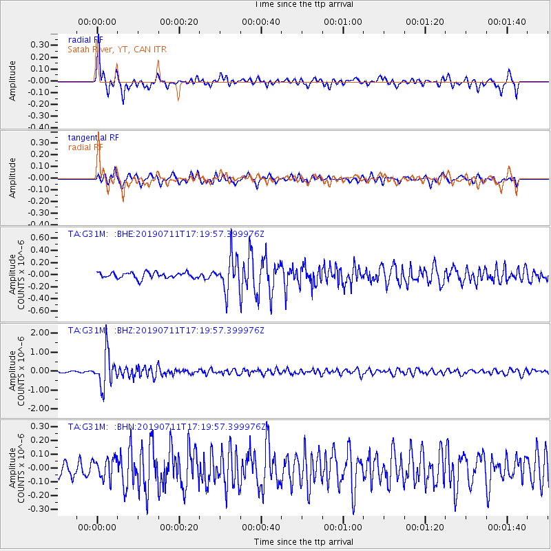
G31M Satah River, YT, CAN - Earthquake Result Viewer
*The percent match for this event was below the threshold and hence no stack was calculated.
| Earthquake location: |
Solomon Islands |
| Earthquake latitude/longitude: |
-4.7/155.2 |
| Earthquake time(UTC): |
2019/07/11 (192) 17:08:37 GMT |
| Earthquake Depth: |
496 km |
| Earthquake Magnitude: |
6.0 Mww |
| Earthquake Catalog/Contributor: |
NEIC PDE/us |
|
| Network: |
TA USArray Transportable Network (new EarthScope stations) |
| Station: |
G31M Satah River, YT, CAN |
| Lat/Lon: |
66.92 N/134.27 W |
| Elevation: |
61 m |
|
| Distance: |
86.7 deg |
| Az: |
21.849 deg |
| Baz: |
250.222 deg |
| Ray Param: |
$rayparam |
*The percent match for this event was below the threshold and hence was not used in the summary stack. |
|
| Radial Match: |
73.802055 % |
| Radial Bump: |
383 |
| Transverse Match: |
59.50889 % |
| Transverse Bump: |
400 |
| SOD ConfigId: |
19053131 |
| Insert Time: |
2019-07-25 17:15:36.774 +0000 |
| GWidth: |
2.5 |
| Max Bumps: |
400 |
| Tol: |
0.001 |
|
Signal To Noise
| Channel | StoN | STA | LTA |
| TA:G31M: :BHZ:20190711T17:19:57.399976Z | 13.140943 | 9.196535E-7 | 6.998383E-8 |
| TA:G31M: :BHN:20190711T17:19:57.399976Z | 1.3658326 | 7.4578665E-8 | 5.4603085E-8 |
| TA:G31M: :BHE:20190711T17:19:57.399976Z | 6.0437427 | 2.900093E-7 | 4.798505E-8 |
| Arrivals |
| Ps | |
| PpPs | |
| PsPs/PpSs | |


