You are here: Home > Network List > TA - USArray Transportable Network (new EarthScope stations) Stations List
> Station M20K Styx River, AK, USA > Earthquake Result Viewer
M20K Styx River, AK, USA - Earthquake Result Viewer
| Earthquake location: |
Solomon Islands |
| Earthquake latitude/longitude: |
-4.7/155.2 |
| Earthquake time(UTC): |
2019/07/11 (192) 17:08:37 GMT |
| Earthquake Depth: |
496 km |
| Earthquake Magnitude: |
6.0 Mww |
| Earthquake Catalog/Contributor: |
NEIC PDE/us |
|
| Network: |
TA USArray Transportable Network (new EarthScope stations) |
| Station: |
M20K Styx River, AK, USA |
| Lat/Lon: |
61.88 N/153.13 W |
| Elevation: |
1107 m |
|
| Distance: |
77.2 deg |
| Az: |
22.39 deg |
| Baz: |
233.265 deg |
| Ray Param: |
0.04900162 |
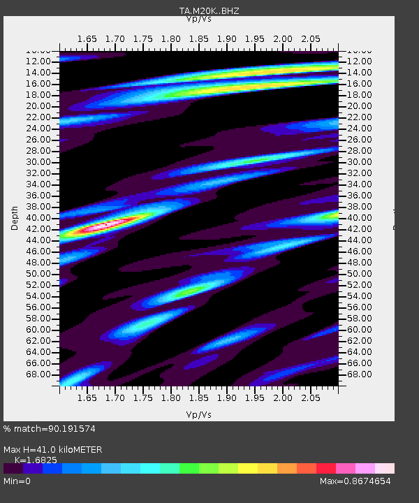
| Estimated Moho Depth: |
41.0 km |
| Estimated Crust Vp/Vs: |
1.68 |
| Assumed Crust Vp: |
6.566 km/s |
| Estimated Crust Vs: |
3.903 km/s |
| Estimated Crust Poisson's Ratio: |
0.23 |
|
| Radial Match: |
90.191574 % |
| Radial Bump: |
377 |
| Transverse Match: |
52.64656 % |
| Transverse Bump: |
400 |
| SOD ConfigId: |
19053131 |
| Insert Time: |
2019-07-25 17:16:09.793 +0000 |
| GWidth: |
2.5 |
| Max Bumps: |
400 |
| Tol: |
0.001 |
|

Signal To Noise
| Channel | StoN | STA | LTA |
| TA:M20K: :BHZ:20190711T17:19:08.849988Z | 10.993634 | 6.509223E-7 | 5.9209018E-8 |
| TA:M20K: :BHN:20190711T17:19:08.849988Z | 7.314451 | 2.7100526E-7 | 3.705066E-8 |
| TA:M20K: :BHE:20190711T17:19:08.849988Z | 10.405396 | 2.9214118E-7 | 2.807593E-8 |
| Arrivals |
| Ps | 4.4 SECOND |
| PpPs | 16 SECOND |
| PsPs/PpSs | 21 SECOND |


