You are here: Home > Network List > TA - USArray Transportable Network (new EarthScope stations) Stations List
> Station M05C Lookout, CA, USA > Earthquake Result Viewer
M05C Lookout, CA, USA - Earthquake Result Viewer
| Earthquake location: |
Near S Coast Of New Guinea, P.N.G. |
| Earthquake latitude/longitude: |
-7.2/146.0 |
| Earthquake time(UTC): |
2005/10/25 (298) 19:40:43 GMT |
| Earthquake Depth: |
175 km |
| Earthquake Magnitude: |
5.8 MB, 5.9 MW, 5.9 MW |
| Earthquake Catalog/Contributor: |
WHDF/NEIC |
|
| Network: |
TA USArray Transportable Network (new EarthScope stations) |
| Station: |
M05C Lookout, CA, USA |
| Lat/Lon: |
41.36 N/121.15 W |
| Elevation: |
1333 m |
|
| Distance: |
96.8 deg |
| Az: |
49.219 deg |
| Baz: |
266.516 deg |
| Ray Param: |
0.040243942 |
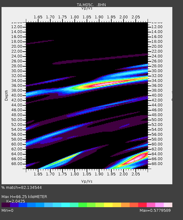
| Estimated Moho Depth: |
66.25 km |
| Estimated Crust Vp/Vs: |
2.04 |
| Assumed Crust Vp: |
6.566 km/s |
| Estimated Crust Vs: |
3.215 km/s |
| Estimated Crust Poisson's Ratio: |
0.34 |
|
| Radial Match: |
82.134544 % |
| Radial Bump: |
279 |
| Transverse Match: |
68.737015 % |
| Transverse Bump: |
378 |
| SOD ConfigId: |
132717 |
| Insert Time: |
2010-03-07 01:36:16.129 +0000 |
| GWidth: |
2.5 |
| Max Bumps: |
400 |
| Tol: |
0.001 |
|

Signal To Noise
| Channel | StoN | STA | LTA |
| TA:M05C: :BHN:20051025T19:53:22.448997Z | 1.1529665 | 5.1859433E-7 | 4.4979132E-7 |
| TA:M05C: :BHE:20051025T19:53:22.448997Z | 0.5529676 | 4.5804495E-7 | 8.283396E-7 |
| TA:M05C: :BHZ:20051025T19:53:22.448997Z | 0.4935951 | 2.7651043E-7 | 5.601969E-7 |
| Arrivals |
| Ps | 11 SECOND |
| PpPs | 30 SECOND |
| PsPs/PpSs | 41 SECOND |


