You are here: Home > Network List > TA - USArray Transportable Network (new EarthScope stations) Stations List
> Station O14K Tigyukauivet Mountain, AK, USA > Earthquake Result Viewer
O14K Tigyukauivet Mountain, AK, USA - Earthquake Result Viewer
| Earthquake location: |
Solomon Islands |
| Earthquake latitude/longitude: |
-4.7/155.2 |
| Earthquake time(UTC): |
2019/07/11 (192) 17:08:37 GMT |
| Earthquake Depth: |
496 km |
| Earthquake Magnitude: |
6.0 Mww |
| Earthquake Catalog/Contributor: |
NEIC PDE/us |
|
| Network: |
TA USArray Transportable Network (new EarthScope stations) |
| Station: |
O14K Tigyukauivet Mountain, AK, USA |
| Lat/Lon: |
59.25 N/161.26 W |
| Elevation: |
129 m |
|
| Distance: |
72.4 deg |
| Az: |
21.775 deg |
| Baz: |
226.027 deg |
| Ray Param: |
0.052094486 |
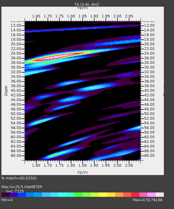
| Estimated Moho Depth: |
25.5 km |
| Estimated Crust Vp/Vs: |
1.72 |
| Assumed Crust Vp: |
6.24 km/s |
| Estimated Crust Vs: |
3.623 km/s |
| Estimated Crust Poisson's Ratio: |
0.25 |
|
| Radial Match: |
80.82501 % |
| Radial Bump: |
400 |
| Transverse Match: |
62.678505 % |
| Transverse Bump: |
400 |
| SOD ConfigId: |
19053131 |
| Insert Time: |
2019-07-25 17:16:20.587 +0000 |
| GWidth: |
2.5 |
| Max Bumps: |
400 |
| Tol: |
0.001 |
|

Signal To Noise
| Channel | StoN | STA | LTA |
| TA:O14K: :BHZ:20190711T17:18:42.149976Z | 9.783651 | 8.597332E-7 | 8.787447E-8 |
| TA:O14K: :BHN:20190711T17:18:42.149976Z | 3.2018485 | 1.8209569E-7 | 5.687205E-8 |
| TA:O14K: :BHE:20190711T17:18:42.149976Z | 2.8160808 | 1.6584319E-7 | 5.8891487E-8 |
| Arrivals |
| Ps | 3.0 SECOND |
| PpPs | 11 SECOND |
| PsPs/PpSs | 14 SECOND |


