You are here: Home > Network List > TA - USArray Transportable Network (new EarthScope stations) Stations List
> Station M05C Lookout, CA, USA > Earthquake Result Viewer
M05C Lookout, CA, USA - Earthquake Result Viewer
| Earthquake location: |
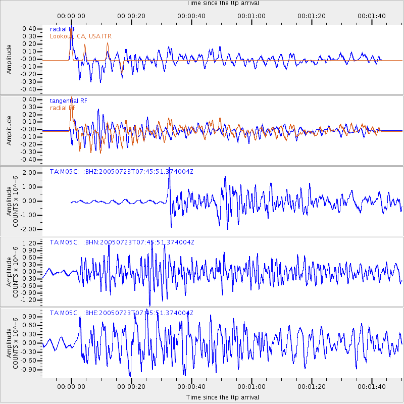
Near S. Coast Of Honshu, Japan |
| Earthquake latitude/longitude: |
35.5/140.0 |
| Earthquake time(UTC): |
2005/07/23 (204) 07:34:56 GMT |
| Earthquake Depth: |
61 km |
| Earthquake Magnitude: |
6.1 MB, 6.0 MW, 6.0 MW |
| Earthquake Catalog/Contributor: |
WHDF/NEIC |
|
| Network: |
TA USArray Transportable Network (new EarthScope stations) |
| Station: |
M05C Lookout, CA, USA |
| Lat/Lon: |
41.36 N/121.15 W |
| Elevation: |
1333 m |
|
| Distance: |
73.4 deg |
| Az: |
50.909 deg |
| Baz: |
302.722 deg |
| Ray Param: |
0.05290696 |
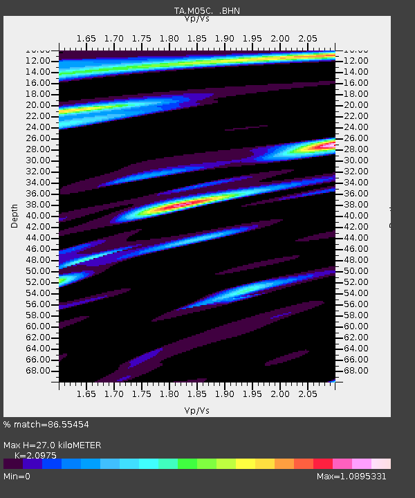
| Estimated Moho Depth: |
27.0 km |
| Estimated Crust Vp/Vs: |
2.10 |
| Assumed Crust Vp: |
6.566 km/s |
| Estimated Crust Vs: |
3.13 km/s |
| Estimated Crust Poisson's Ratio: |
0.35 |
|
| Radial Match: |
86.55454 % |
| Radial Bump: |
395 |
| Transverse Match: |
77.482956 % |
| Transverse Bump: |
400 |
| SOD ConfigId: |
2475 |
| Insert Time: |
2010-03-07 01:36:26.734 +0000 |
| GWidth: |
2.5 |
| Max Bumps: |
400 |
| Tol: |
0.001 |
|
Signal To Noise
| Channel | StoN | STA | LTA |
| TA:M05C: :BHN:20050723T07:45:51.374004Z | 2.012779 | 2.7935377E-7 | 1.3879009E-7 |
| TA:M05C: :BHE:20050723T07:45:51.374004Z | 2.8038752 | 3.3894543E-7 | 1.2088464E-7 |
| TA:M05C: :BHZ:20050723T07:45:51.374004Z | 10.034971 | 8.447539E-7 | 8.4181E-8 |
| Arrivals |
| Ps | 4.6 SECOND |
| PpPs | 12 SECOND |
| PsPs/PpSs | 17 SECOND |


