You are here: Home > Network List > TA - USArray Transportable Network (new EarthScope stations) Stations List
> Station R33M Jennings River, BC, CAN > Earthquake Result Viewer
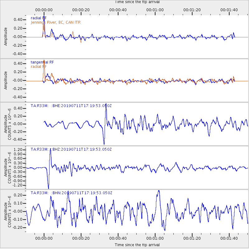
R33M Jennings River, BC, CAN - Earthquake Result Viewer
*The percent match for this event was below the threshold and hence no stack was calculated.
| Earthquake location: |
Solomon Islands |
| Earthquake latitude/longitude: |
-4.7/155.2 |
| Earthquake time(UTC): |
2019/07/11 (192) 17:08:37 GMT |
| Earthquake Depth: |
496 km |
| Earthquake Magnitude: |
6.0 Mww |
| Earthquake Catalog/Contributor: |
NEIC PDE/us |
|
| Network: |
TA USArray Transportable Network (new EarthScope stations) |
| Station: |
R33M Jennings River, BC, CAN |
| Lat/Lon: |
59.39 N/130.97 W |
| Elevation: |
1437 m |
|
| Distance: |
85.8 deg |
| Az: |
29.513 deg |
| Baz: |
253.672 deg |
| Ray Param: |
$rayparam |
*The percent match for this event was below the threshold and hence was not used in the summary stack. |
|
| Radial Match: |
69.97086 % |
| Radial Bump: |
397 |
| Transverse Match: |
51.27956 % |
| Transverse Bump: |
395 |
| SOD ConfigId: |
19053131 |
| Insert Time: |
2019-07-25 17:16:37.218 +0000 |
| GWidth: |
2.5 |
| Max Bumps: |
400 |
| Tol: |
0.001 |
|
Signal To Noise
| Channel | StoN | STA | LTA |
| TA:R33M: :BHZ:20190711T17:19:53.050Z | 19.862144 | 6.219002E-7 | 3.131083E-8 |
| TA:R33M: :BHN:20190711T17:19:53.050Z | 1.0334591 | 8.99492E-8 | 8.703702E-8 |
| TA:R33M: :BHE:20190711T17:19:53.050Z | 4.26628 | 2.3382184E-7 | 5.4806954E-8 |
| Arrivals |
| Ps | |
| PpPs | |
| PsPs/PpSs | |


