You are here: Home > Network List > IU - Global Seismograph Network (GSN - IRIS/USGS) Stations List
> Station AFI Afiamalu, Samoa > Earthquake Result Viewer
AFI Afiamalu, Samoa - Earthquake Result Viewer
| Earthquake location: |
New Ireland Region, P.N.G. |
| Earthquake latitude/longitude: |
-4.5/153.6 |
| Earthquake time(UTC): |
2016/12/17 (352) 10:51:11 GMT |
| Earthquake Depth: |
73 km |
| Earthquake Magnitude: |
8.0 Mi |
| Earthquake Catalog/Contributor: |
NEIC PDE/pt |
|
| Network: |
IU Global Seismograph Network (GSN - IRIS/USGS) |
| Station: |
AFI Afiamalu, Samoa |
| Lat/Lon: |
13.91 S/171.78 W |
| Elevation: |
706 m |
|
| Distance: |
35.4 deg |
| Az: |
107.706 deg |
| Baz: |
282.02 deg |
| Ray Param: |
0.07701855 |
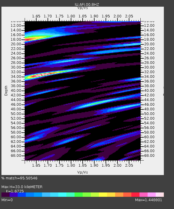
| Estimated Moho Depth: |
33.0 km |
| Estimated Crust Vp/Vs: |
1.67 |
| Assumed Crust Vp: |
4.24 km/s |
| Estimated Crust Vs: |
2.535 km/s |
| Estimated Crust Poisson's Ratio: |
0.22 |
|
| Radial Match: |
95.58546 % |
| Radial Bump: |
400 |
| Transverse Match: |
75.18315 % |
| Transverse Bump: |
400 |
| SOD ConfigId: |
1894071 |
| Insert Time: |
2016-12-31 10:52:49.673 +0000 |
| GWidth: |
2.5 |
| Max Bumps: |
400 |
| Tol: |
0.001 |
|
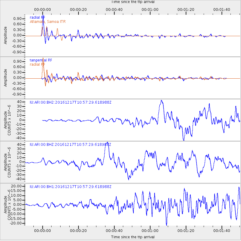
Signal To Noise
| Channel | StoN | STA | LTA |
| IU:AFI:00:BHZ:20161217T10:57:29.618988Z | 7.9137783 | 5.1867696E-6 | 6.5541E-7 |
| IU:AFI:00:BH1:20161217T10:57:29.618988Z | 1.4924698 | 1.7199307E-6 | 1.1524057E-6 |
| IU:AFI:00:BH2:20161217T10:57:29.618988Z | 4.021247 | 4.5724855E-6 | 1.1370814E-6 |
| Arrivals |
| Ps | 5.4 SECOND |
| PpPs | 20 SECOND |
| PsPs/PpSs | 26 SECOND |


