You are here: Home > Network List > UW - Pacific Northwest Regional Seismic Network Stations List
> Station LEBA Lebam, WA, USA > Earthquake Result Viewer
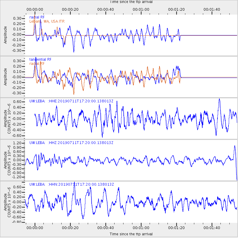
LEBA Lebam, WA, USA - Earthquake Result Viewer
*The percent match for this event was below the threshold and hence no stack was calculated.
| Earthquake location: |
Solomon Islands |
| Earthquake latitude/longitude: |
-4.7/155.2 |
| Earthquake time(UTC): |
2019/07/11 (192) 17:08:37 GMT |
| Earthquake Depth: |
496 km |
| Earthquake Magnitude: |
6.0 Mww |
| Earthquake Catalog/Contributor: |
NEIC PDE/us |
|
| Network: |
UW Pacific Northwest Regional Seismic Network |
| Station: |
LEBA Lebam, WA, USA |
| Lat/Lon: |
46.55 N/123.56 W |
| Elevation: |
73 m |
|
| Distance: |
87.3 deg |
| Az: |
43.064 deg |
| Baz: |
260.426 deg |
| Ray Param: |
$rayparam |
*The percent match for this event was below the threshold and hence was not used in the summary stack. |
|
| Radial Match: |
62.372204 % |
| Radial Bump: |
382 |
| Transverse Match: |
45.041714 % |
| Transverse Bump: |
330 |
| SOD ConfigId: |
19053131 |
| Insert Time: |
2019-07-25 17:17:33.701 +0000 |
| GWidth: |
2.5 |
| Max Bumps: |
400 |
| Tol: |
0.001 |
|
Signal To Noise
| Channel | StoN | STA | LTA |
| UW:LEBA: :HHZ:20190711T17:20:00.138013Z | 1.7605461 | 3.4268578E-7 | 1.9464743E-7 |
| UW:LEBA: :HHN:20190711T17:20:00.138013Z | 1.0593529 | 1.7885594E-7 | 1.688351E-7 |
| UW:LEBA: :HHE:20190711T17:20:00.138013Z | 1.0837023 | 1.942514E-7 | 1.7924793E-7 |
| Arrivals |
| Ps | |
| PpPs | |
| PsPs/PpSs | |


