You are here: Home > Network List > TA - USArray Transportable Network (new EarthScope stations) Stations List
> Station M05C Lookout, CA, USA > Earthquake Result Viewer
M05C Lookout, CA, USA - Earthquake Result Viewer
| Earthquake location: |
Vanuatu Islands |
| Earthquake latitude/longitude: |
-19.2/168.7 |
| Earthquake time(UTC): |
2007/08/05 (217) 09:28:40 GMT |
| Earthquake Depth: |
45 km |
| Earthquake Magnitude: |
5.6 MB, 5.5 MS, 6.0 MW, 5.9 MW |
| Earthquake Catalog/Contributor: |
WHDF/NEIC |
|
| Network: |
TA USArray Transportable Network (new EarthScope stations) |
| Station: |
M05C Lookout, CA, USA |
| Lat/Lon: |
41.36 N/121.15 W |
| Elevation: |
1333 m |
|
| Distance: |
88.4 deg |
| Az: |
45.094 deg |
| Baz: |
242.8 deg |
| Ray Param: |
0.042508595 |
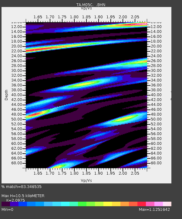
| Estimated Moho Depth: |
10.5 km |
| Estimated Crust Vp/Vs: |
2.10 |
| Assumed Crust Vp: |
6.566 km/s |
| Estimated Crust Vs: |
3.13 km/s |
| Estimated Crust Poisson's Ratio: |
0.35 |
|
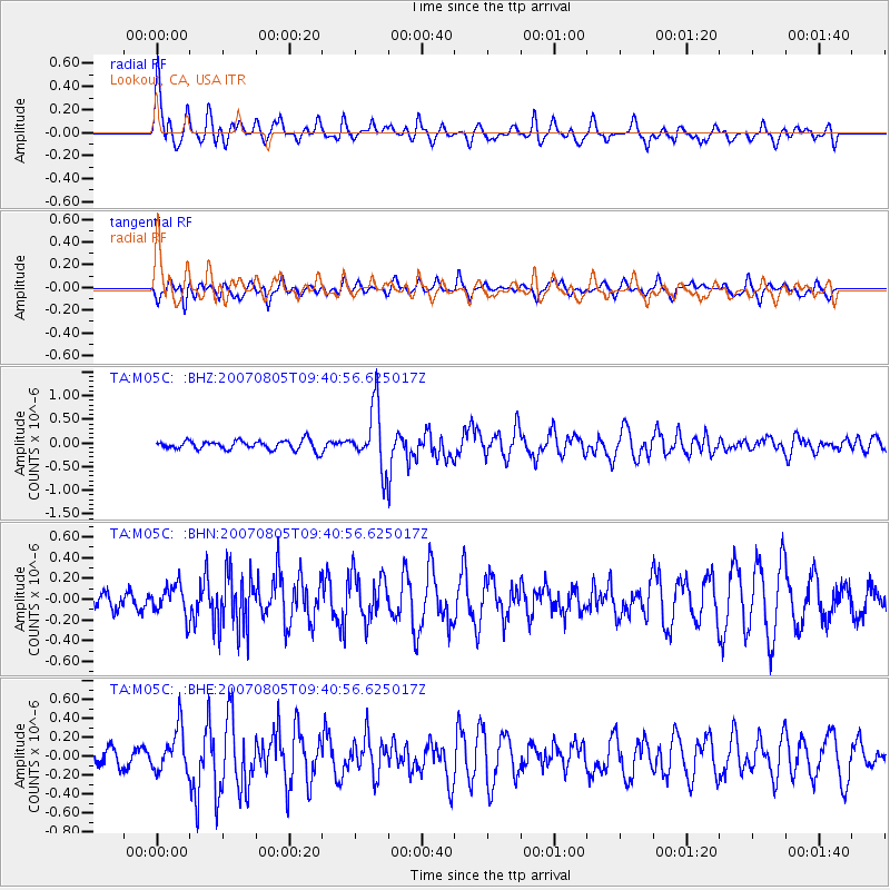
| Radial Match: |
83.346535 % |
| Radial Bump: |
400 |
| Transverse Match: |
48.911766 % |
| Transverse Bump: |
400 |
| SOD ConfigId: |
2564 |
| Insert Time: |
2010-03-07 01:36:57.770 +0000 |
| GWidth: |
2.5 |
| Max Bumps: |
400 |
| Tol: |
0.001 |
|
Signal To Noise
| Channel | StoN | STA | LTA |
| TA:M05C: :BHN:20070805T09:40:56.625017Z | 1.1162964 | 1.4598609E-7 | 1.3077718E-7 |
| TA:M05C: :BHE:20070805T09:40:56.625017Z | 1.1477308 | 2.2710007E-7 | 1.9786877E-7 |
| TA:M05C: :BHZ:20070805T09:40:56.625017Z | 6.508208 | 6.425738E-7 | 9.873283E-8 |
| Arrivals |
| Ps | 1.8 SECOND |
| PpPs | 4.9 SECOND |
| PsPs/PpSs | 6.6 SECOND |


