You are here: Home > Network List > TA - USArray Transportable Network (new EarthScope stations) Stations List
> Station M05C Lookout, CA, USA > Earthquake Result Viewer
M05C Lookout, CA, USA - Earthquake Result Viewer

| Earthquake location: |
Komandorskiye Ostrova Region |
| Earthquake latitude/longitude: |
53.6/169.7 |
| Earthquake time(UTC): |
2007/07/29 (210) 04:54:36 GMT |
| Earthquake Depth: |
26 km |
| Earthquake Magnitude: |
6.0 MB, 5.5 MS, 5.9 MW, 5.8 MW |
| Earthquake Catalog/Contributor: |
WHDF/NEIC |
|
| Network: |
TA USArray Transportable Network (new EarthScope stations) |
| Station: |
M05C Lookout, CA, USA |
| Lat/Lon: |
41.36 N/121.15 W |
| Elevation: |
1333 m |
|
| Distance: |
46.5 deg |
| Az: |
75.9 deg |
| Baz: |
309.903 deg |
| Ray Param: |
0.070565455 |
| Estimated Moho Depth: |
27.75 km |
| Estimated Crust Vp/Vs: |
2.05 |
| Assumed Crust Vp: |
6.566 km/s |
| Estimated Crust Vs: |
3.207 km/s |
| Estimated Crust Poisson's Ratio: |
0.34 |
|
| Radial Match: |
82.54935 % |
| Radial Bump: |
400 |
| Transverse Match: |
78.67646 % |
| Transverse Bump: |
400 |
| SOD ConfigId: |
2564 |
| Insert Time: |
2010-03-07 01:37:01.003 +0000 |
| GWidth: |
2.5 |
| Max Bumps: |
400 |
| Tol: |
0.001 |
|
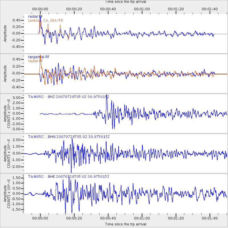
Signal To Noise
| Channel | StoN | STA | LTA |
| TA:M05C: :BHN:20070729T05:02:30.975015Z | 2.8727334 | 1.5651827E-7 | 5.4484094E-8 |
| TA:M05C: :BHE:20070729T05:02:30.975015Z | 1.8085681 | 1.1068714E-7 | 6.120153E-8 |
| TA:M05C: :BHZ:20070729T05:02:30.975015Z | 4.1121974 | 2.731226E-7 | 6.641768E-8 |
| Arrivals |
| Ps | 4.7 SECOND |
| PpPs | 12 SECOND |
| PsPs/PpSs | 17 SECOND |


