You are here: Home > Network List > TA - USArray Transportable Network (new EarthScope stations) Stations List
> Station M05C Lookout, CA, USA > Earthquake Result Viewer
M05C Lookout, CA, USA - Earthquake Result Viewer
| Earthquake location: |
Southeast Of Loyalty Islands |
| Earthquake latitude/longitude: |
-21.5/170.9 |
| Earthquake time(UTC): |
2007/07/27 (208) 14:46:26 GMT |
| Earthquake Depth: |
10 km |
| Earthquake Magnitude: |
6.0 MB, 6.0 MS, 6.1 MW, 6.1 MW |
| Earthquake Catalog/Contributor: |
WHDF/NEIC |
|
| Network: |
TA USArray Transportable Network (new EarthScope stations) |
| Station: |
M05C Lookout, CA, USA |
| Lat/Lon: |
41.36 N/121.15 W |
| Elevation: |
1333 m |
|
| Distance: |
88.6 deg |
| Az: |
44.247 deg |
| Baz: |
239.702 deg |
| Ray Param: |
0.042457223 |
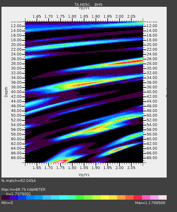
| Estimated Moho Depth: |
69.75 km |
| Estimated Crust Vp/Vs: |
1.74 |
| Assumed Crust Vp: |
6.566 km/s |
| Estimated Crust Vs: |
3.779 km/s |
| Estimated Crust Poisson's Ratio: |
0.25 |
|
| Radial Match: |
92.0454 % |
| Radial Bump: |
400 |
| Transverse Match: |
87.63999 % |
| Transverse Bump: |
400 |
| SOD ConfigId: |
2564 |
| Insert Time: |
2010-03-07 01:37:02.521 +0000 |
| GWidth: |
2.5 |
| Max Bumps: |
400 |
| Tol: |
0.001 |
|
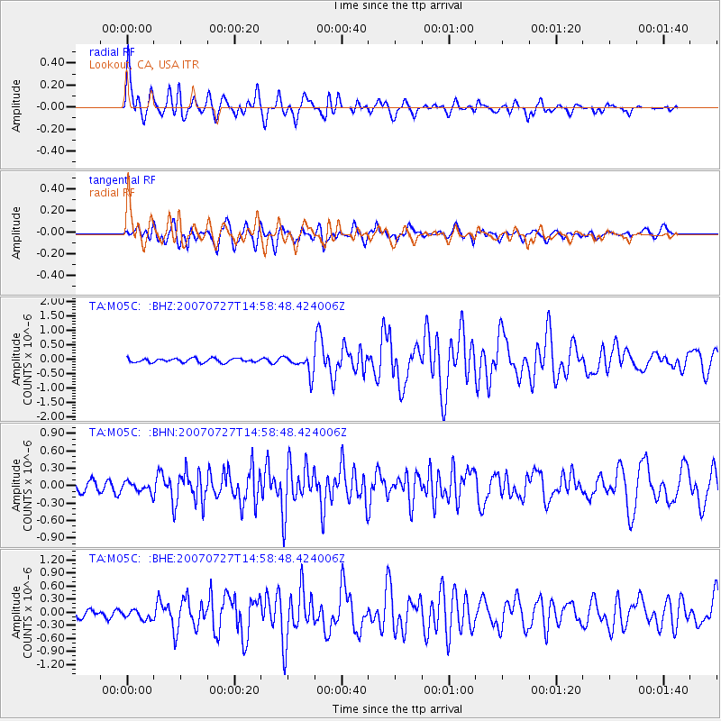
Signal To Noise
| Channel | StoN | STA | LTA |
| TA:M05C: :BHN:20070727T14:58:48.424006Z | 1.1141762 | 8.5088125E-8 | 7.636865E-8 |
| TA:M05C: :BHE:20070727T14:58:48.424006Z | 0.9510855 | 1.03969356E-7 | 1.0931652E-7 |
| TA:M05C: :BHZ:20070727T14:58:48.424006Z | 5.072684 | 3.3938656E-7 | 6.690473E-8 |
| Arrivals |
| Ps | 8.0 SECOND |
| PpPs | 28 SECOND |
| PsPs/PpSs | 36 SECOND |


