You are here: Home > Network List > IU - Global Seismograph Network (GSN - IRIS/USGS) Stations List
> Station JOHN Johnston Island, USA > Earthquake Result Viewer
JOHN Johnston Island, USA - Earthquake Result Viewer
| Earthquake location: |
New Ireland Region, P.N.G. |
| Earthquake latitude/longitude: |
-4.5/153.6 |
| Earthquake time(UTC): |
2016/12/17 (352) 10:51:11 GMT |
| Earthquake Depth: |
73 km |
| Earthquake Magnitude: |
8.0 Mi |
| Earthquake Catalog/Contributor: |
NEIC PDE/pt |
|
| Network: |
IU Global Seismograph Network (GSN - IRIS/USGS) |
| Station: |
JOHN Johnston Island, USA |
| Lat/Lon: |
16.73 N/169.53 W |
| Elevation: |
2.0 m |
|
| Distance: |
42.1 deg |
| Az: |
59.071 deg |
| Baz: |
243.195 deg |
| Ray Param: |
0.07314777 |
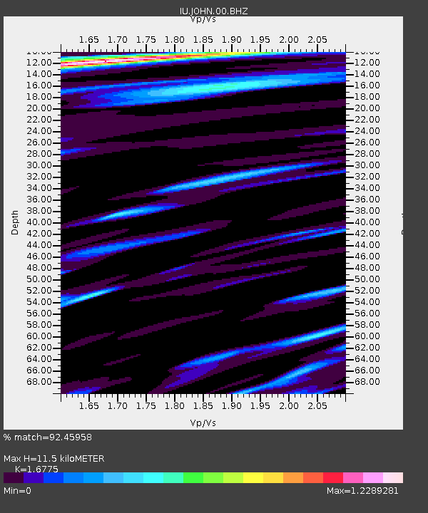
| Estimated Moho Depth: |
11.5 km |
| Estimated Crust Vp/Vs: |
1.68 |
| Assumed Crust Vp: |
4.24 km/s |
| Estimated Crust Vs: |
2.528 km/s |
| Estimated Crust Poisson's Ratio: |
0.22 |
|
| Radial Match: |
92.45958 % |
| Radial Bump: |
400 |
| Transverse Match: |
79.576485 % |
| Transverse Bump: |
400 |
| SOD ConfigId: |
1894071 |
| Insert Time: |
2016-12-31 10:53:02.179 +0000 |
| GWidth: |
2.5 |
| Max Bumps: |
400 |
| Tol: |
0.001 |
|

Signal To Noise
| Channel | StoN | STA | LTA |
| IU:JOHN:00:BHZ:20161217T10:58:25.493988Z | 3.0271587 | 8.956261E-6 | 2.958636E-6 |
| IU:JOHN:00:BH1:20161217T10:58:25.493988Z | 1.0917202 | 4.2841916E-6 | 3.9242577E-6 |
| IU:JOHN:00:BH2:20161217T10:58:25.493988Z | 0.7395384 | 3.6362305E-6 | 4.9168925E-6 |
| Arrivals |
| Ps | 1.9 SECOND |
| PpPs | 7.1 SECOND |
| PsPs/PpSs | 8.9 SECOND |


