You are here: Home > Network List > TA - USArray Transportable Network (new EarthScope stations) Stations List
> Station M05C Lookout, CA, USA > Earthquake Result Viewer
M05C Lookout, CA, USA - Earthquake Result Viewer

| Earthquake location: |
Vanuatu Islands |
| Earthquake latitude/longitude: |
-15.4/168.6 |
| Earthquake time(UTC): |
2007/07/15 (196) 09:27:34 GMT |
| Earthquake Depth: |
8.0 km |
| Earthquake Magnitude: |
6.0 MB, 5.8 MS, 6.1 MW, 6.0 MW |
| Earthquake Catalog/Contributor: |
WHDF/NEIC |
|
| Network: |
TA USArray Transportable Network (new EarthScope stations) |
| Station: |
M05C Lookout, CA, USA |
| Lat/Lon: |
41.36 N/121.15 W |
| Elevation: |
1333 m |
|
| Distance: |
85.9 deg |
| Az: |
45.264 deg |
| Baz: |
245.543 deg |
| Ray Param: |
0.04444796 |
| Estimated Moho Depth: |
36.5 km |
| Estimated Crust Vp/Vs: |
1.82 |
| Assumed Crust Vp: |
6.566 km/s |
| Estimated Crust Vs: |
3.608 km/s |
| Estimated Crust Poisson's Ratio: |
0.28 |
|
| Radial Match: |
92.69967 % |
| Radial Bump: |
400 |
| Transverse Match: |
87.24919 % |
| Transverse Bump: |
400 |
| SOD ConfigId: |
2564 |
| Insert Time: |
2010-03-07 01:37:10.102 +0000 |
| GWidth: |
2.5 |
| Max Bumps: |
400 |
| Tol: |
0.001 |
|
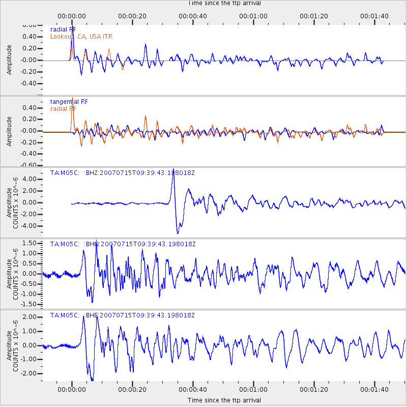
Signal To Noise
| Channel | StoN | STA | LTA |
| TA:M05C: :BHN:20070715T09:39:43.198018Z | 6.2953243 | 4.286703E-7 | 6.809344E-8 |
| TA:M05C: :BHE:20070715T09:39:43.198018Z | 7.2332597 | 7.4194804E-7 | 1.02574504E-7 |
| TA:M05C: :BHZ:20070715T09:39:43.198018Z | 26.936872 | 2.26432E-6 | 8.406025E-8 |
| Arrivals |
| Ps | 4.7 SECOND |
| PpPs | 15 SECOND |
| PsPs/PpSs | 20 SECOND |


