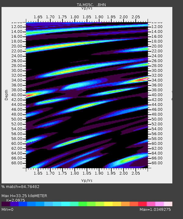
M05C Lookout, CA, USA - Earthquake Result Viewer
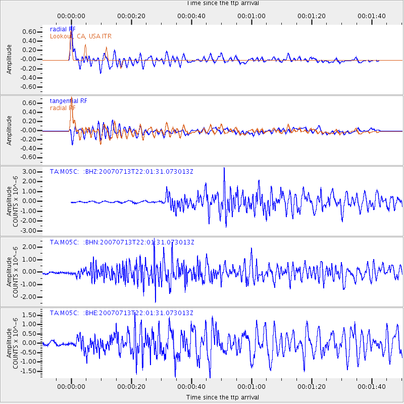
Earthquake location: Andreanof Islands, Aleutian Is.
Earthquake latitude/longitude: 51.8/-176.3
Earthquake time(UTC): 2007/07/13 (194) 21:54:43 GMT
Earthquake Depth: 35 km
Earthquake Magnitude: 5.7 MB, 5.6 MS, 6.0 MW, 5.9 MW
Earthquake Catalog/Contributor: WHDF/NEIC
Network: TA USArray Transportable Network (new EarthScope stations)
Station: M05C Lookout, CA, USA
Lat/Lon: 41.36 N/121.15 W
Elevation: 1333 m
Distance: 38.4 deg
Az: 83.448 deg
Baz: 305.032 deg
Ray Param: 0.07549032
Estimated Moho Depth: 33.25 km
Estimated Crust Vp/Vs: 2.10
Assumed Crust Vp: 6.566 km/s
Estimated Crust Vs: 3.13 km/s
Estimated Crust Poisson's Ratio: 0.35
Radial Match: 84.76482 %
Radial Bump: 400
Transverse Match: 72.44057 %
Transverse Bump: 400
SOD ConfigId: 2564
Insert Time: 2010-03-07 01:37:11.979 +0000
GWidth: 2.5
Max Bumps: 400
Tol: 0.001

Signal To Noise

ChannelStoNSTALTA
TA:M05C: :BHN:20070713T22:01:31.073013Z3.34024982.1429977E-76.415681E-8
TA:M05C: :BHE:20070713T22:01:31.073013Z3.50744442.817601E-78.0332015E-8
TA:M05C: :BHZ:20070713T22:01:31.073013Z8.3627786.1074377E-77.303121E-8
Arrivals
Ps5.9 SECOND
PpPs15 SECOND
PsPs/PpSs21 SECOND