You are here: Home > Network List > TA - USArray Transportable Network (new EarthScope stations) Stations List
> Station M05C Lookout, CA, USA > Earthquake Result Viewer
M05C Lookout, CA, USA - Earthquake Result Viewer
| Earthquake location: |
Kyushu, Japan |
| Earthquake latitude/longitude: |
33.1/131.1 |
| Earthquake time(UTC): |
2006/06/11 (162) 20:01:26 GMT |
| Earthquake Depth: |
140 km |
| Earthquake Magnitude: |
5.9 MB, 6.3 MW, 6.3 MW |
| Earthquake Catalog/Contributor: |
WHDF/NEIC |
|
| Network: |
TA USArray Transportable Network (new EarthScope stations) |
| Station: |
M05C Lookout, CA, USA |
| Lat/Lon: |
41.36 N/121.15 W |
| Elevation: |
1333 m |
|
| Distance: |
80.5 deg |
| Az: |
46.649 deg |
| Baz: |
305.849 deg |
| Ray Param: |
0.047943857 |
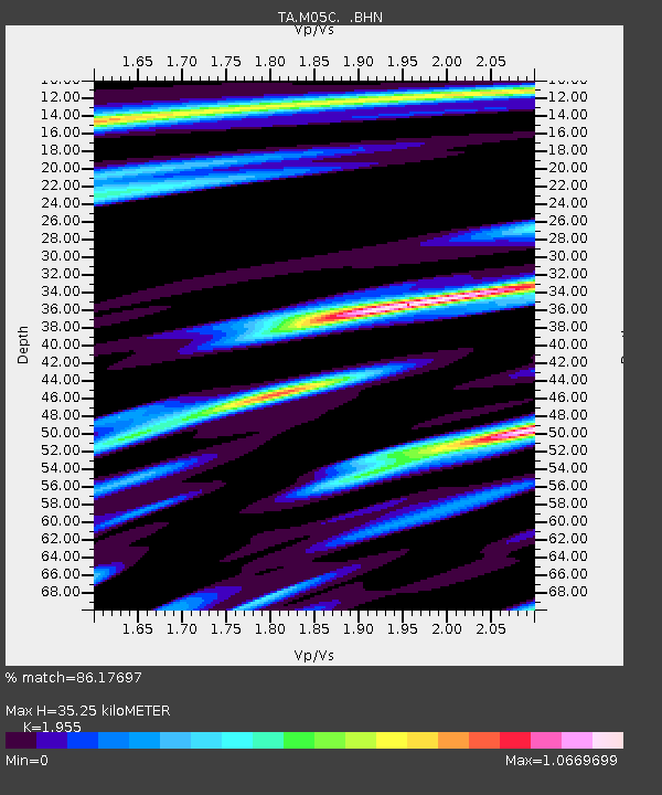
| Estimated Moho Depth: |
35.25 km |
| Estimated Crust Vp/Vs: |
1.96 |
| Assumed Crust Vp: |
6.566 km/s |
| Estimated Crust Vs: |
3.359 km/s |
| Estimated Crust Poisson's Ratio: |
0.32 |
|
| Radial Match: |
86.17697 % |
| Radial Bump: |
400 |
| Transverse Match: |
76.40553 % |
| Transverse Bump: |
400 |
| SOD ConfigId: |
5423 |
| Insert Time: |
2010-03-07 01:37:23.455 +0000 |
| GWidth: |
2.5 |
| Max Bumps: |
400 |
| Tol: |
0.001 |
|
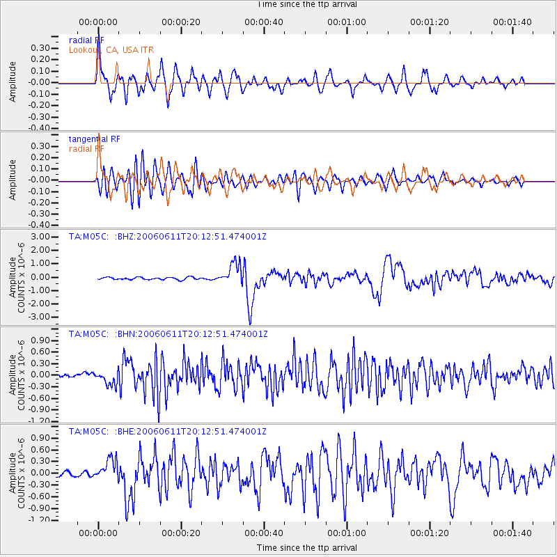
Signal To Noise
| Channel | StoN | STA | LTA |
| TA:M05C: :BHN:20060611T20:12:51.474001Z | 1.4209404 | 1.6605117E-7 | 1.1686004E-7 |
| TA:M05C: :BHE:20060611T20:12:51.474001Z | 2.645464 | 2.9735122E-7 | 1.1240041E-7 |
| TA:M05C: :BHZ:20060611T20:12:51.474001Z | 9.703056 | 8.3811307E-7 | 8.63762E-8 |
| Arrivals |
| Ps | 5.3 SECOND |
| PpPs | 15 SECOND |
| PsPs/PpSs | 21 SECOND |


