You are here: Home > Network List > IU - Global Seismograph Network (GSN - IRIS/USGS) Stations List
> Station POHA Pohakuloa, Hawaii, USA > Earthquake Result Viewer
POHA Pohakuloa, Hawaii, USA - Earthquake Result Viewer
| Earthquake location: |
New Ireland Region, P.N.G. |
| Earthquake latitude/longitude: |
-4.5/153.6 |
| Earthquake time(UTC): |
2016/12/17 (352) 10:51:11 GMT |
| Earthquake Depth: |
73 km |
| Earthquake Magnitude: |
8.0 Mi |
| Earthquake Catalog/Contributor: |
NEIC PDE/pt |
|
| Network: |
IU Global Seismograph Network (GSN - IRIS/USGS) |
| Station: |
POHA Pohakuloa, Hawaii, USA |
| Lat/Lon: |
19.76 N/155.53 W |
| Elevation: |
1990 m |
|
| Distance: |
55.5 deg |
| Az: |
62.462 deg |
| Baz: |
249.821 deg |
| Ray Param: |
0.06454391 |
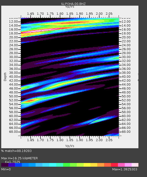
| Estimated Moho Depth: |
16.25 km |
| Estimated Crust Vp/Vs: |
1.70 |
| Assumed Crust Vp: |
5.195 km/s |
| Estimated Crust Vs: |
3.051 km/s |
| Estimated Crust Poisson's Ratio: |
0.24 |
|
| Radial Match: |
88.19283 % |
| Radial Bump: |
400 |
| Transverse Match: |
72.04351 % |
| Transverse Bump: |
400 |
| SOD ConfigId: |
1894071 |
| Insert Time: |
2016-12-31 10:53:09.462 +0000 |
| GWidth: |
2.5 |
| Max Bumps: |
400 |
| Tol: |
0.001 |
|

Signal To Noise
| Channel | StoN | STA | LTA |
| IU:POHA:00:BHZ:20161217T11:00:07.869019Z | 2.029698 | 9.402266E-6 | 4.6323476E-6 |
| IU:POHA:00:BH1:20161217T11:00:07.869019Z | 0.8936276 | 2.476683E-6 | 2.7714932E-6 |
| IU:POHA:00:BH2:20161217T11:00:07.869019Z | 1.6939899 | 9.098605E-6 | 5.371109E-6 |
| Arrivals |
| Ps | 2.3 SECOND |
| PpPs | 8.2 SECOND |
| PsPs/PpSs | 10 SECOND |


