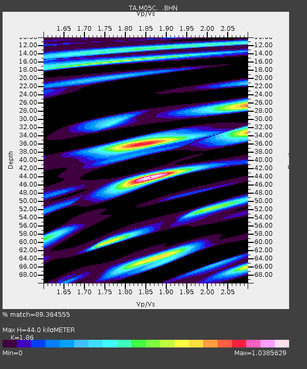
M05C Lookout, CA, USA - Earthquake Result Viewer
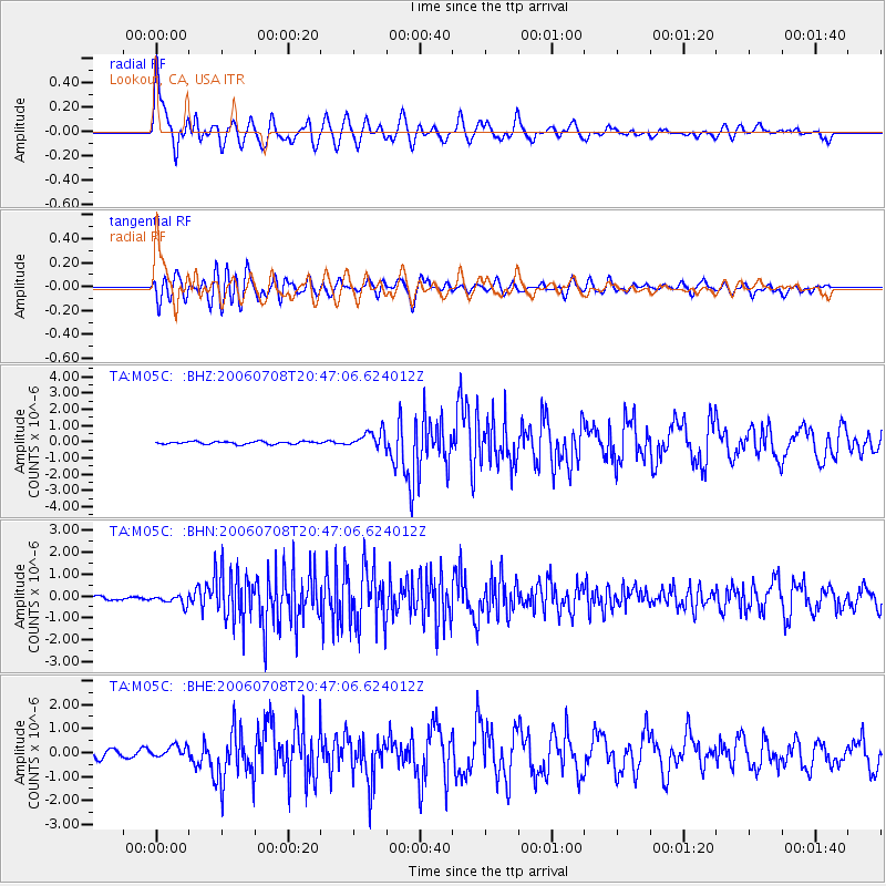
Earthquake location: Andreanof Islands, Aleutian Is.
Earthquake latitude/longitude: 51.2/-179.3
Earthquake time(UTC): 2006/07/08 (189) 20:40:00 GMT
Earthquake Depth: 22 km
Earthquake Magnitude: 6.2 MB, 6.4 MS, 6.6 MW, 6.6 MW
Earthquake Catalog/Contributor: WHDF/NEIC
Network: TA USArray Transportable Network (new EarthScope stations)
Station: M05C Lookout, CA, USA
Lat/Lon: 41.36 N/121.15 W
Elevation: 1333 m
Distance: 40.4 deg
Az: 80.646 deg
Baz: 304.47 deg
Ray Param: 0.07439159
Estimated Moho Depth: 44.0 km
Estimated Crust Vp/Vs: 1.86
Assumed Crust Vp: 6.566 km/s
Estimated Crust Vs: 3.53 km/s
Estimated Crust Poisson's Ratio: 0.30
Radial Match: 89.364555 %
Radial Bump: 400
Transverse Match: 74.64007 %
Transverse Bump: 400
SOD ConfigId: 2665
Insert Time: 2010-03-07 01:37:31.342 +0000
GWidth: 2.5
Max Bumps: 400
Tol: 0.001

Signal To Noise

ChannelStoNSTALTA
TA:M05C: :BHN:20060708T20:47:06.624012Z1.99024582.2276978E-71.1193079E-7
TA:M05C: :BHE:20060708T20:47:06.624012Z1.53615622.4640315E-71.604024E-7
TA:M05C: :BHZ:20060708T20:47:06.624012Z6.33231265.2613836E-78.308787E-8
Arrivals
Ps6.2 SECOND
PpPs18 SECOND
PsPs/PpSs24 SECOND