You are here: Home > Network List > TA - USArray Transportable Network (new EarthScope stations) Stations List
> Station M05C Lookout, CA, USA > Earthquake Result Viewer
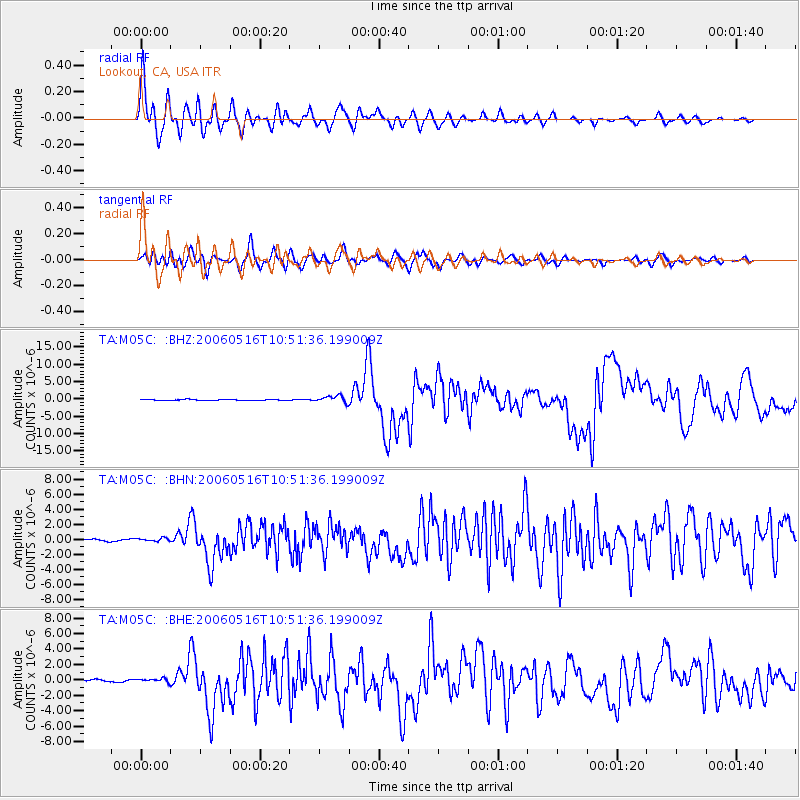
M05C Lookout, CA, USA - Earthquake Result Viewer

| Earthquake location: |
Kermadec Islands Region |
| Earthquake latitude/longitude: |
-31.8/-179.3 |
| Earthquake time(UTC): |
2006/05/16 (136) 10:39:23 GMT |
| Earthquake Depth: |
152 km |
| Earthquake Magnitude: |
6.8 MB, 7.4 MW, 7.4 MW |
| Earthquake Catalog/Contributor: |
WHDF/NEIC |
|
| Network: |
TA USArray Transportable Network (new EarthScope stations) |
| Station: |
M05C Lookout, CA, USA |
| Lat/Lon: |
41.36 N/121.15 W |
| Elevation: |
1333 m |
|
| Distance: |
90.4 deg |
| Az: |
39.76 deg |
| Baz: |
226.351 deg |
| Ray Param: |
0.04164483 |
| Estimated Moho Depth: |
26.75 km |
| Estimated Crust Vp/Vs: |
2.10 |
| Assumed Crust Vp: |
6.566 km/s |
| Estimated Crust Vs: |
3.13 km/s |
| Estimated Crust Poisson's Ratio: |
0.35 |
|
| Radial Match: |
92.9378 % |
| Radial Bump: |
400 |
| Transverse Match: |
79.89884 % |
| Transverse Bump: |
400 |
| SOD ConfigId: |
2669 |
| Insert Time: |
2010-03-07 01:37:37.610 +0000 |
| GWidth: |
2.5 |
| Max Bumps: |
400 |
| Tol: |
0.001 |
|
Signal To Noise
| Channel | StoN | STA | LTA |
| TA:M05C: :BHN:20060516T10:51:36.199009Z | 1.0006773 | 2.0967266E-7 | 2.0953074E-7 |
| TA:M05C: :BHE:20060516T10:51:36.199009Z | 1.3174314 | 2.4572617E-7 | 1.8651913E-7 |
| TA:M05C: :BHZ:20060516T10:51:36.199009Z | 6.611007 | 9.994817E-7 | 1.5118448E-7 |
| Arrivals |
| Ps | 4.6 SECOND |
| PpPs | 12 SECOND |
| PsPs/PpSs | 17 SECOND |


