You are here: Home > Network List > IU - Global Seismograph Network (GSN - IRIS/USGS) Stations List
> Station SNZO South Karori, New Zealand > Earthquake Result Viewer
SNZO South Karori, New Zealand - Earthquake Result Viewer
| Earthquake location: |
New Ireland Region, P.N.G. |
| Earthquake latitude/longitude: |
-4.5/153.6 |
| Earthquake time(UTC): |
2016/12/17 (352) 10:51:11 GMT |
| Earthquake Depth: |
73 km |
| Earthquake Magnitude: |
8.0 Mi |
| Earthquake Catalog/Contributor: |
NEIC PDE/pt |
|
| Network: |
IU Global Seismograph Network (GSN - IRIS/USGS) |
| Station: |
SNZO South Karori, New Zealand |
| Lat/Lon: |
41.31 S/174.70 E |
| Elevation: |
120 m |
|
| Distance: |
41.3 deg |
| Az: |
155.692 deg |
| Baz: |
326.992 deg |
| Ray Param: |
0.07365824 |
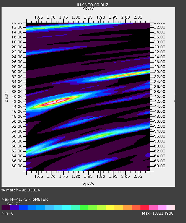
| Estimated Moho Depth: |
41.75 km |
| Estimated Crust Vp/Vs: |
1.72 |
| Assumed Crust Vp: |
6.461 km/s |
| Estimated Crust Vs: |
3.757 km/s |
| Estimated Crust Poisson's Ratio: |
0.24 |
|
| Radial Match: |
96.83014 % |
| Radial Bump: |
400 |
| Transverse Match: |
91.67224 % |
| Transverse Bump: |
400 |
| SOD ConfigId: |
1894071 |
| Insert Time: |
2016-12-31 10:53:16.645 +0000 |
| GWidth: |
2.5 |
| Max Bumps: |
400 |
| Tol: |
0.001 |
|
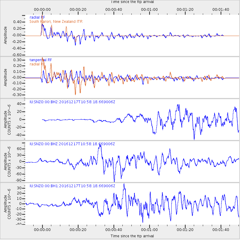
Signal To Noise
| Channel | StoN | STA | LTA |
| IU:SNZO:00:BHZ:20161217T10:58:18.669006Z | 7.014481 | 6.389316E-6 | 9.1087503E-7 |
| IU:SNZO:00:BH1:20161217T10:58:18.669006Z | 3.0156631 | 2.4896465E-6 | 8.2557176E-7 |
| IU:SNZO:00:BH2:20161217T10:58:18.669006Z | 4.112434 | 3.6916288E-6 | 8.9767485E-7 |
| Arrivals |
| Ps | 5.0 SECOND |
| PpPs | 16 SECOND |
| PsPs/PpSs | 21 SECOND |


