You are here: Home > Network List > TA - USArray Transportable Network (new EarthScope stations) Stations List
> Station M05C Lookout, CA, USA > Earthquake Result Viewer
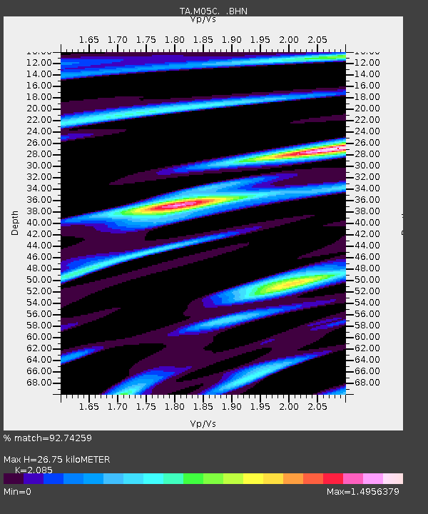
M05C Lookout, CA, USA - Earthquake Result Viewer
| Earthquake location: |
Fiji Islands Region |
| Earthquake latitude/longitude: |
-19.9/-178.2 |
| Earthquake time(UTC): |
2006/01/02 (002) 22:13:40 GMT |
| Earthquake Depth: |
583 km |
| Earthquake Magnitude: |
6.5 MB, 7.2 MW, 7.1 MW |
| Earthquake Catalog/Contributor: |
WHDF/NEIC |
|
| Network: |
TA USArray Transportable Network (new EarthScope stations) |
| Station: |
M05C Lookout, CA, USA |
| Lat/Lon: |
41.36 N/121.15 W |
| Elevation: |
1333 m |
|
| Distance: |
80.7 deg |
| Az: |
39.796 deg |
| Baz: |
233.128 deg |
| Ray Param: |
0.046353158 |
| Estimated Moho Depth: |
26.75 km |
| Estimated Crust Vp/Vs: |
2.09 |
| Assumed Crust Vp: |
6.566 km/s |
| Estimated Crust Vs: |
3.149 km/s |
| Estimated Crust Poisson's Ratio: |
0.35 |
|
| Radial Match: |
92.74259 % |
| Radial Bump: |
400 |
| Transverse Match: |
82.68715 % |
| Transverse Bump: |
400 |
| SOD ConfigId: |
2422 |
| Insert Time: |
2010-03-07 01:37:52.094 +0000 |
| GWidth: |
2.5 |
| Max Bumps: |
400 |
| Tol: |
0.001 |
|

Signal To Noise
| Channel | StoN | STA | LTA |
| TA:M05C: :BHN:20060102T22:24:22.273997Z | 3.3091486 | 3.6063666E-6 | 1.089817E-6 |
| TA:M05C: :BHE:20060102T22:24:22.273997Z | 6.7640696 | 4.6152627E-6 | 6.8232043E-7 |
| TA:M05C: :BHZ:20060102T22:24:22.273997Z | 26.666815 | 1.3759013E-5 | 5.1596015E-7 |
| Arrivals |
| Ps | 4.5 SECOND |
| PpPs | 12 SECOND |
| PsPs/PpSs | 17 SECOND |


