You are here: Home > Network List > TA - USArray Transportable Network (new EarthScope stations) Stations List
> Station M05C Lookout, CA, USA > Earthquake Result Viewer
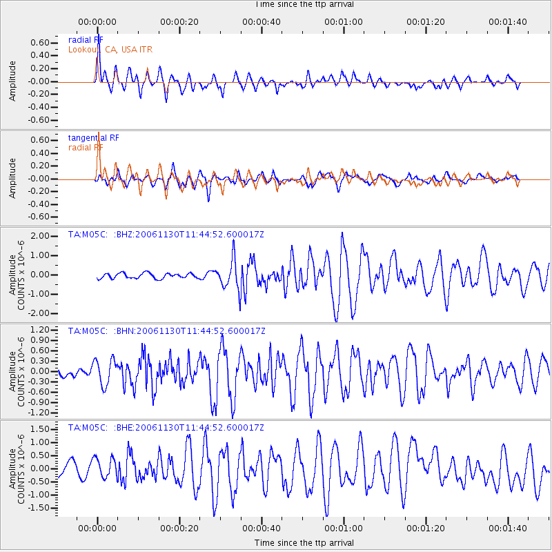
M05C Lookout, CA, USA - Earthquake Result Viewer
| Earthquake location: |
Tonga Islands |
| Earthquake latitude/longitude: |
-21.3/-174.7 |
| Earthquake time(UTC): |
2006/11/30 (334) 11:33:17 GMT |
| Earthquake Depth: |
14 km |
| Earthquake Magnitude: |
5.7 MB, 6.1 MS, 6.0 MW, 6.0 MW |
| Earthquake Catalog/Contributor: |
WHDF/NEIC |
|
| Network: |
TA USArray Transportable Network (new EarthScope stations) |
| Station: |
M05C Lookout, CA, USA |
| Lat/Lon: |
41.36 N/121.15 W |
| Elevation: |
1333 m |
|
| Distance: |
79.7 deg |
| Az: |
37.979 deg |
| Baz: |
229.668 deg |
| Ray Param: |
0.04880509 |
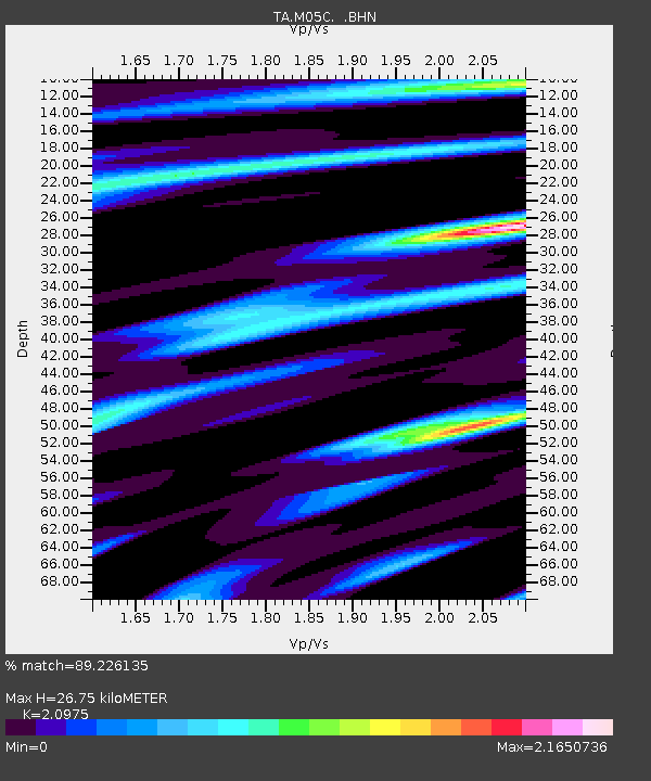
| Estimated Moho Depth: |
26.75 km |
| Estimated Crust Vp/Vs: |
2.10 |
| Assumed Crust Vp: |
6.566 km/s |
| Estimated Crust Vs: |
3.13 km/s |
| Estimated Crust Poisson's Ratio: |
0.35 |
|
| Radial Match: |
89.226135 % |
| Radial Bump: |
400 |
| Transverse Match: |
60.195305 % |
| Transverse Bump: |
400 |
| SOD ConfigId: |
2564 |
| Insert Time: |
2010-03-07 01:38:03.035 +0000 |
| GWidth: |
2.5 |
| Max Bumps: |
400 |
| Tol: |
0.001 |
|
Signal To Noise
| Channel | StoN | STA | LTA |
| TA:M05C: :BHN:20061130T11:44:52.600017Z | 1.717539 | 3.81608E-7 | 2.2218303E-7 |
| TA:M05C: :BHE:20061130T11:44:52.600017Z | 1.4388388 | 3.9532821E-7 | 2.7475502E-7 |
| TA:M05C: :BHZ:20061130T11:44:52.600017Z | 5.910735 | 7.80061E-7 | 1.319736E-7 |
| Arrivals |
| Ps | 4.6 SECOND |
| PpPs | 12 SECOND |
| PsPs/PpSs | 17 SECOND |


