You are here: Home > Network List > TA - USArray Transportable Network (new EarthScope stations) Stations List
> Station K09A Rome, OR, USA > Earthquake Result Viewer
K09A Rome, OR, USA - Earthquake Result Viewer
| Earthquake location: |
South Of Fiji Islands |
| Earthquake latitude/longitude: |
-26.0/-177.5 |
| Earthquake time(UTC): |
2007/12/09 (343) 07:28:20 GMT |
| Earthquake Depth: |
152 km |
| Earthquake Magnitude: |
7.0 MB, 7.8 MW, 7.7 MW |
| Earthquake Catalog/Contributor: |
WHDF/NEIC |
|
| Network: |
TA USArray Transportable Network (new EarthScope stations) |
| Station: |
K09A Rome, OR, USA |
| Lat/Lon: |
42.70 N/117.73 W |
| Elevation: |
1176 m |
|
| Distance: |
87.7 deg |
| Az: |
39.609 deg |
| Baz: |
231.109 deg |
| Ray Param: |
0.04275495 |
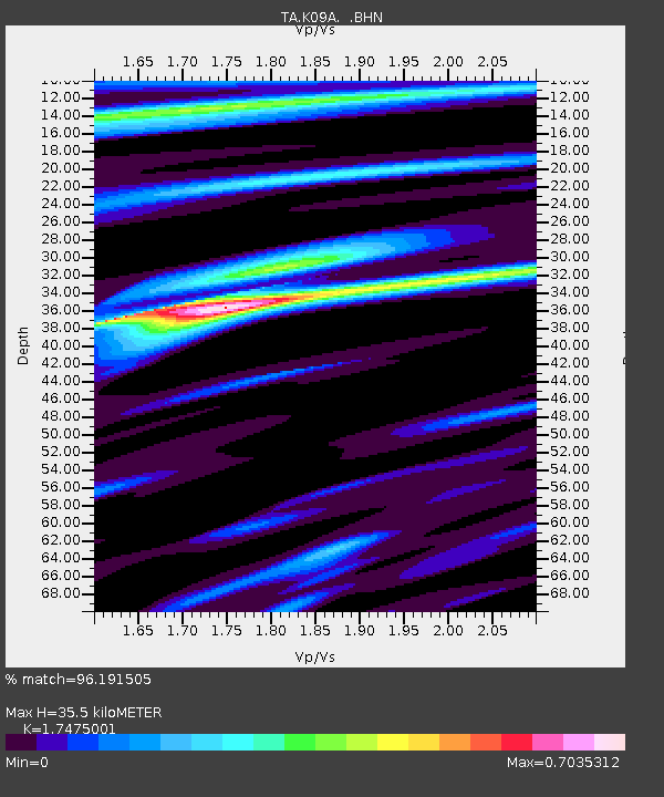
| Estimated Moho Depth: |
35.5 km |
| Estimated Crust Vp/Vs: |
1.75 |
| Assumed Crust Vp: |
6.291 km/s |
| Estimated Crust Vs: |
3.6 km/s |
| Estimated Crust Poisson's Ratio: |
0.26 |
|
| Radial Match: |
96.191505 % |
| Radial Bump: |
256 |
| Transverse Match: |
84.42696 % |
| Transverse Bump: |
400 |
| SOD ConfigId: |
2564 |
| Insert Time: |
2010-03-07 01:38:09.591 +0000 |
| GWidth: |
2.5 |
| Max Bumps: |
400 |
| Tol: |
0.001 |
|
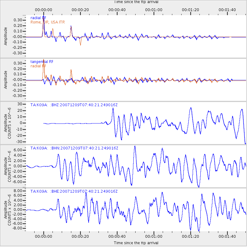
Signal To Noise
| Channel | StoN | STA | LTA |
| TA:K09A: :BHN:20071209T07:40:21.249016Z | 1.228705 | 2.1577252E-7 | 1.7560969E-7 |
| TA:K09A: :BHE:20071209T07:40:21.249016Z | 2.3648896 | 3.738353E-7 | 1.5807727E-7 |
| TA:K09A: :BHZ:20071209T07:40:21.249016Z | 4.69305 | 1.1203913E-6 | 2.3873415E-7 |
| Arrivals |
| Ps | 4.3 SECOND |
| PpPs | 15 SECOND |
| PsPs/PpSs | 19 SECOND |


