You are here: Home > Network List > TA - USArray Transportable Network (new EarthScope stations) Stations List
> Station K09A Rome, OR, USA > Earthquake Result Viewer
K09A Rome, OR, USA - Earthquake Result Viewer
| Earthquake location: |
Peru-Ecuador Border Region |
| Earthquake latitude/longitude: |
-2.3/-77.8 |
| Earthquake time(UTC): |
2007/11/16 (320) 03:13:00 GMT |
| Earthquake Depth: |
123 km |
| Earthquake Magnitude: |
6.3 MB, 6.8 MW, 6.7 MW |
| Earthquake Catalog/Contributor: |
WHDF/NEIC |
|
| Network: |
TA USArray Transportable Network (new EarthScope stations) |
| Station: |
K09A Rome, OR, USA |
| Lat/Lon: |
42.70 N/117.73 W |
| Elevation: |
1176 m |
|
| Distance: |
57.4 deg |
| Az: |
325.884 deg |
| Baz: |
130.517 deg |
| Ray Param: |
0.06311627 |
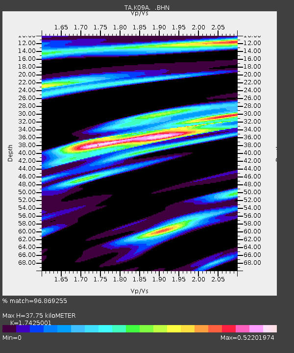
| Estimated Moho Depth: |
37.75 km |
| Estimated Crust Vp/Vs: |
1.74 |
| Assumed Crust Vp: |
6.291 km/s |
| Estimated Crust Vs: |
3.61 km/s |
| Estimated Crust Poisson's Ratio: |
0.25 |
|
| Radial Match: |
96.869255 % |
| Radial Bump: |
279 |
| Transverse Match: |
62.658752 % |
| Transverse Bump: |
362 |
| SOD ConfigId: |
2564 |
| Insert Time: |
2010-03-07 01:38:13.296 +0000 |
| GWidth: |
2.5 |
| Max Bumps: |
400 |
| Tol: |
0.001 |
|

Signal To Noise
| Channel | StoN | STA | LTA |
| TA:K09A: :BHN:20071116T03:22:05.424016Z | 2.0190632 | 8.2033927E-7 | 4.0629695E-7 |
| TA:K09A: :BHE:20071116T03:22:05.424016Z | 1.689517 | 8.107809E-7 | 4.7988914E-7 |
| TA:K09A: :BHZ:20071116T03:22:05.424016Z | 10.635145 | 3.6708136E-6 | 3.4515878E-7 |
| Arrivals |
| Ps | 4.7 SECOND |
| PpPs | 16 SECOND |
| PsPs/PpSs | 20 SECOND |


