You are here: Home > Network List > TA - USArray Transportable Network (new EarthScope stations) Stations List
> Station K09A Rome, OR, USA > Earthquake Result Viewer
K09A Rome, OR, USA - Earthquake Result Viewer
| Earthquake location: |
South Of Fiji Islands |
| Earthquake latitude/longitude: |
-25.8/179.5 |
| Earthquake time(UTC): |
2007/10/16 (289) 21:05:43 GMT |
| Earthquake Depth: |
509 km |
| Earthquake Magnitude: |
6.2 MB, 6.6 MW, 6.5 MW |
| Earthquake Catalog/Contributor: |
WHDF/NEIC |
|
| Network: |
TA USArray Transportable Network (new EarthScope stations) |
| Station: |
K09A Rome, OR, USA |
| Lat/Lon: |
42.70 N/117.73 W |
| Elevation: |
1176 m |
|
| Distance: |
89.3 deg |
| Az: |
40.949 deg |
| Baz: |
233.283 deg |
| Ray Param: |
0.041620288 |
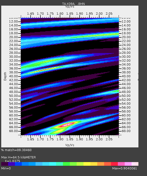
| Estimated Moho Depth: |
64.5 km |
| Estimated Crust Vp/Vs: |
1.84 |
| Assumed Crust Vp: |
6.291 km/s |
| Estimated Crust Vs: |
3.424 km/s |
| Estimated Crust Poisson's Ratio: |
0.29 |
|
| Radial Match: |
89.38468 % |
| Radial Bump: |
386 |
| Transverse Match: |
84.09085 % |
| Transverse Bump: |
400 |
| SOD ConfigId: |
2564 |
| Insert Time: |
2010-03-07 01:38:19.709 +0000 |
| GWidth: |
2.5 |
| Max Bumps: |
400 |
| Tol: |
0.001 |
|

Signal To Noise
| Channel | StoN | STA | LTA |
| TA:K09A: :BHN:20071016T21:17:13.499004Z | 6.0126247 | 7.8914087E-7 | 1.3124732E-7 |
| TA:K09A: :BHE:20071016T21:17:13.499004Z | 8.625878 | 9.906615E-7 | 1.1484761E-7 |
| TA:K09A: :BHZ:20071016T21:17:13.499004Z | 25.756367 | 4.6292994E-6 | 1.7973419E-7 |
| Arrivals |
| Ps | 8.8 SECOND |
| PpPs | 29 SECOND |
| PsPs/PpSs | 37 SECOND |


