You are here: Home > Network List > TA - USArray Transportable Network (new EarthScope stations) Stations List
> Station K09A Rome, OR, USA > Earthquake Result Viewer
K09A Rome, OR, USA - Earthquake Result Viewer
| Earthquake location: |
South Of Mariana Islands |
| Earthquake latitude/longitude: |
10.5/145.7 |
| Earthquake time(UTC): |
2007/09/30 (273) 02:08:30 GMT |
| Earthquake Depth: |
14 km |
| Earthquake Magnitude: |
6.4 MB, 7.1 MS, 6.9 MW, 6.9 MW |
| Earthquake Catalog/Contributor: |
WHDF/NEIC |
|
| Network: |
TA USArray Transportable Network (new EarthScope stations) |
| Station: |
K09A Rome, OR, USA |
| Lat/Lon: |
42.70 N/117.73 W |
| Elevation: |
1176 m |
|
| Distance: |
87.8 deg |
| Az: |
47.132 deg |
| Baz: |
282.061 deg |
| Ray Param: |
0.04308036 |
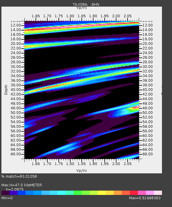
| Estimated Moho Depth: |
47.0 km |
| Estimated Crust Vp/Vs: |
2.10 |
| Assumed Crust Vp: |
6.291 km/s |
| Estimated Crust Vs: |
2.999 km/s |
| Estimated Crust Poisson's Ratio: |
0.35 |
|
| Radial Match: |
93.01059 % |
| Radial Bump: |
400 |
| Transverse Match: |
76.25749 % |
| Transverse Bump: |
400 |
| SOD ConfigId: |
2564 |
| Insert Time: |
2010-03-07 01:38:21.145 +0000 |
| GWidth: |
2.5 |
| Max Bumps: |
400 |
| Tol: |
0.001 |
|

Signal To Noise
| Channel | StoN | STA | LTA |
| TA:K09A: :BHN:20070930T02:20:47.024004Z | 0.6623157 | 9.490713E-8 | 1.432959E-7 |
| TA:K09A: :BHE:20070930T02:20:47.024004Z | 1.3502517 | 1.6940663E-7 | 1.25463E-7 |
| TA:K09A: :BHZ:20070930T02:20:47.024004Z | 5.607037 | 7.0086594E-7 | 1.2499756E-7 |
| Arrivals |
| Ps | 8.3 SECOND |
| PpPs | 23 SECOND |
| PsPs/PpSs | 31 SECOND |


