You are here: Home > Network List > TA - USArray Transportable Network (new EarthScope stations) Stations List
> Station K09A Rome, OR, USA > Earthquake Result Viewer
K09A Rome, OR, USA - Earthquake Result Viewer
| Earthquake location: |
Kuril Islands |
| Earthquake latitude/longitude: |
45.8/150.1 |
| Earthquake time(UTC): |
2007/09/03 (246) 16:14:53 GMT |
| Earthquake Depth: |
94 km |
| Earthquake Magnitude: |
6.3 MB, 6.2 MW, 6.2 ME |
| Earthquake Catalog/Contributor: |
WHDF/NEIC |
|
| Network: |
TA USArray Transportable Network (new EarthScope stations) |
| Station: |
K09A Rome, OR, USA |
| Lat/Lon: |
42.70 N/117.73 W |
| Elevation: |
1176 m |
|
| Distance: |
62.4 deg |
| Az: |
56.22 deg |
| Baz: |
307.977 deg |
| Ray Param: |
0.059992444 |
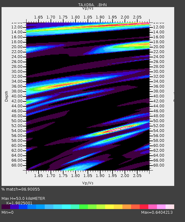
| Estimated Moho Depth: |
53.0 km |
| Estimated Crust Vp/Vs: |
1.98 |
| Assumed Crust Vp: |
6.291 km/s |
| Estimated Crust Vs: |
3.173 km/s |
| Estimated Crust Poisson's Ratio: |
0.33 |
|
| Radial Match: |
86.90855 % |
| Radial Bump: |
360 |
| Transverse Match: |
78.818886 % |
| Transverse Bump: |
400 |
| SOD ConfigId: |
2564 |
| Insert Time: |
2010-03-07 01:38:28.010 +0000 |
| GWidth: |
2.5 |
| Max Bumps: |
400 |
| Tol: |
0.001 |
|

Signal To Noise
| Channel | StoN | STA | LTA |
| TA:K09A: :BHN:20070903T16:24:35.825005Z | 3.7342756 | 4.355431E-7 | 1.1663389E-7 |
| TA:K09A: :BHE:20070903T16:24:35.825005Z | 10.821709 | 8.711467E-7 | 8.049992E-8 |
| TA:K09A: :BHZ:20070903T16:24:35.825005Z | 23.755095 | 2.35698E-6 | 9.921999E-8 |
| Arrivals |
| Ps | 8.6 SECOND |
| PpPs | 24 SECOND |
| PsPs/PpSs | 33 SECOND |


