You are here: Home > Network List > AV - Alaska Volcano Observatory Stations List
> Station PLBL Mt. Peulik Volcano, Alaska > Earthquake Result Viewer
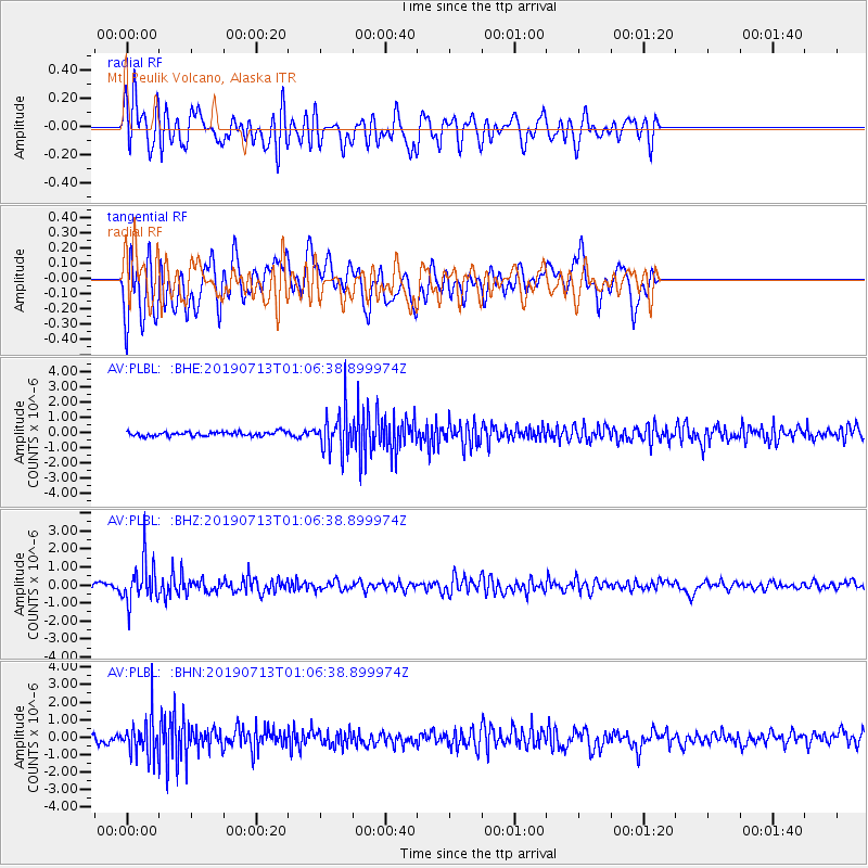
PLBL Mt. Peulik Volcano, Alaska - Earthquake Result Viewer
*The percent match for this event was below the threshold and hence no stack was calculated.
| Earthquake location: |
Northwest Of Ryukyu Islands |
| Earthquake latitude/longitude: |
29.4/128.2 |
| Earthquake time(UTC): |
2019/07/13 (194) 00:57:44 GMT |
| Earthquake Depth: |
251 km |
| Earthquake Magnitude: |
6.1 Mww |
| Earthquake Catalog/Contributor: |
NEIC PDE/us |
|
| Network: |
AV Alaska Volcano Observatory |
| Station: |
PLBL Mt. Peulik Volcano, Alaska |
| Lat/Lon: |
57.70 N/156.82 W |
| Elevation: |
461 m |
|
| Distance: |
57.8 deg |
| Az: |
37.794 deg |
| Baz: |
274.85 deg |
| Ray Param: |
$rayparam |
*The percent match for this event was below the threshold and hence was not used in the summary stack. |
|
| Radial Match: |
62.82839 % |
| Radial Bump: |
400 |
| Transverse Match: |
69.06456 % |
| Transverse Bump: |
400 |
| SOD ConfigId: |
19053131 |
| Insert Time: |
2019-07-27 01:00:19.463 +0000 |
| GWidth: |
2.5 |
| Max Bumps: |
400 |
| Tol: |
0.001 |
|
Signal To Noise
| Channel | StoN | STA | LTA |
| AV:PLBL: :BHZ:20190713T01:06:38.899974Z | 11.938756 | 1.1819945E-6 | 9.9004836E-8 |
| AV:PLBL: :BHN:20190713T01:06:38.899974Z | 6.505401 | 1.0655906E-6 | 1.638009E-7 |
| AV:PLBL: :BHE:20190713T01:06:38.899974Z | 9.69584 | 1.3542434E-6 | 1.3967262E-7 |
| Arrivals |
| Ps | |
| PpPs | |
| PsPs/PpSs | |


