You are here: Home > Network List > TA - USArray Transportable Network (new EarthScope stations) Stations List
> Station K09A Rome, OR, USA > Earthquake Result Viewer
K09A Rome, OR, USA - Earthquake Result Viewer
| Earthquake location: |
Central East Pacific Rise |
| Earthquake latitude/longitude: |
-4.8/-105.4 |
| Earthquake time(UTC): |
2007/08/04 (216) 14:24:51 GMT |
| Earthquake Depth: |
10 km |
| Earthquake Magnitude: |
5.7 MS, 5.4 MB, 6.0 MW, 5.9 MW |
| Earthquake Catalog/Contributor: |
WHDF/NEIC |
|
| Network: |
TA USArray Transportable Network (new EarthScope stations) |
| Station: |
K09A Rome, OR, USA |
| Lat/Lon: |
42.70 N/117.73 W |
| Elevation: |
1176 m |
|
| Distance: |
48.6 deg |
| Az: |
347.892 deg |
| Baz: |
163.528 deg |
| Ray Param: |
0.069268264 |
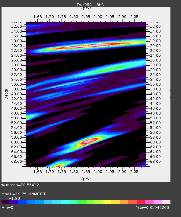
| Estimated Moho Depth: |
19.75 km |
| Estimated Crust Vp/Vs: |
1.86 |
| Assumed Crust Vp: |
6.291 km/s |
| Estimated Crust Vs: |
3.382 km/s |
| Estimated Crust Poisson's Ratio: |
0.30 |
|
| Radial Match: |
88.56412 % |
| Radial Bump: |
400 |
| Transverse Match: |
75.007576 % |
| Transverse Bump: |
400 |
| SOD ConfigId: |
2564 |
| Insert Time: |
2010-03-07 01:38:41.311 +0000 |
| GWidth: |
2.5 |
| Max Bumps: |
400 |
| Tol: |
0.001 |
|

Signal To Noise
| Channel | StoN | STA | LTA |
| TA:K09A: :BHN:20070804T14:33:04.199012Z | 1.8095509 | 6.158523E-8 | 3.4033437E-8 |
| TA:K09A: :BHE:20070804T14:33:04.199012Z | 0.64968663 | 4.6042594E-8 | 7.086893E-8 |
| TA:K09A: :BHZ:20070804T14:33:04.199012Z | 2.2236836 | 2.0810383E-7 | 9.358518E-8 |
| Arrivals |
| Ps | 2.9 SECOND |
| PpPs | 8.5 SECOND |
| PsPs/PpSs | 11 SECOND |


