You are here: Home > Network List > TA - USArray Transportable Network (new EarthScope stations) Stations List
> Station K09A Rome, OR, USA > Earthquake Result Viewer
K09A Rome, OR, USA - Earthquake Result Viewer
| Earthquake location: |
Jujuy Province, Argentina |
| Earthquake latitude/longitude: |
-22.2/-65.8 |
| Earthquake time(UTC): |
2007/07/21 (202) 15:34:52 GMT |
| Earthquake Depth: |
290 km |
| Earthquake Magnitude: |
5.8 MB, 6.4 MW, 6.3 MW |
| Earthquake Catalog/Contributor: |
WHDF/NEIC |
|
| Network: |
TA USArray Transportable Network (new EarthScope stations) |
| Station: |
K09A Rome, OR, USA |
| Lat/Lon: |
42.70 N/117.73 W |
| Elevation: |
1176 m |
|
| Distance: |
80.3 deg |
| Az: |
323.924 deg |
| Baz: |
132.222 deg |
| Ray Param: |
0.047590654 |
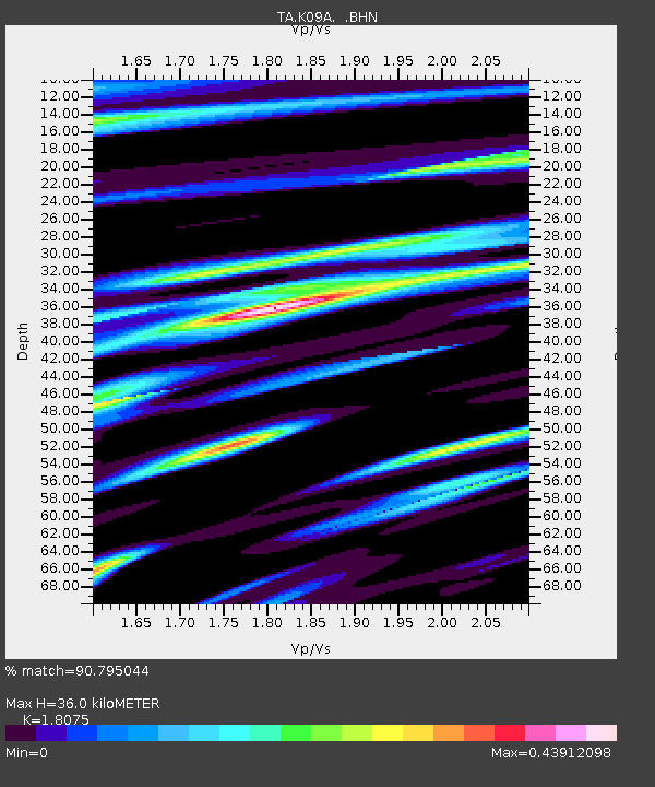
| Estimated Moho Depth: |
36.0 km |
| Estimated Crust Vp/Vs: |
1.81 |
| Assumed Crust Vp: |
6.291 km/s |
| Estimated Crust Vs: |
3.481 km/s |
| Estimated Crust Poisson's Ratio: |
0.28 |
|
| Radial Match: |
90.795044 % |
| Radial Bump: |
400 |
| Transverse Match: |
81.895836 % |
| Transverse Bump: |
400 |
| SOD ConfigId: |
2564 |
| Insert Time: |
2010-03-07 01:38:53.164 +0000 |
| GWidth: |
2.5 |
| Max Bumps: |
400 |
| Tol: |
0.001 |
|

Signal To Noise
| Channel | StoN | STA | LTA |
| TA:K09A: :BHN:20070721T15:46:00.649011Z | 0.8294121 | 7.13102E-8 | 8.5976794E-8 |
| TA:K09A: :BHE:20070721T15:46:00.649011Z | 1.7783347 | 1.2210081E-7 | 6.86602E-8 |
| TA:K09A: :BHZ:20070721T15:46:00.649011Z | 3.118886 | 2.547625E-7 | 8.1683815E-8 |
| Arrivals |
| Ps | 4.7 SECOND |
| PpPs | 16 SECOND |
| PsPs/PpSs | 20 SECOND |


