You are here: Home > Network List > CC - Cascade Chain Volcano Monitoring Stations List
> Station HUSB The Husband > Earthquake Result Viewer
HUSB The Husband - Earthquake Result Viewer
| Earthquake location: |
Northwest Of Ryukyu Islands |
| Earthquake latitude/longitude: |
29.4/128.2 |
| Earthquake time(UTC): |
2019/07/13 (194) 00:57:44 GMT |
| Earthquake Depth: |
251 km |
| Earthquake Magnitude: |
6.1 Mww |
| Earthquake Catalog/Contributor: |
NEIC PDE/us |
|
| Network: |
CC Cascade Chain Volcano Monitoring |
| Station: |
HUSB The Husband |
| Lat/Lon: |
44.12 N/121.85 W |
| Elevation: |
2038 m |
|
| Distance: |
82.9 deg |
| Az: |
43.001 deg |
| Baz: |
304.24 deg |
| Ray Param: |
0.045923263 |
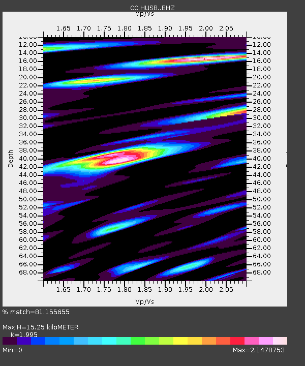
| Estimated Moho Depth: |
15.25 km |
| Estimated Crust Vp/Vs: |
2.00 |
| Assumed Crust Vp: |
6.597 km/s |
| Estimated Crust Vs: |
3.307 km/s |
| Estimated Crust Poisson's Ratio: |
0.33 |
|
| Radial Match: |
81.155655 % |
| Radial Bump: |
400 |
| Transverse Match: |
74.51126 % |
| Transverse Bump: |
400 |
| SOD ConfigId: |
19053131 |
| Insert Time: |
2019-07-27 01:01:14.735 +0000 |
| GWidth: |
2.5 |
| Max Bumps: |
400 |
| Tol: |
0.001 |
|

Signal To Noise
| Channel | StoN | STA | LTA |
| CC:HUSB: :BHZ:20190713T01:09:09.820018Z | 11.042182 | 1.1894522E-6 | 1.0771895E-7 |
| CC:HUSB: :BHN:20190713T01:09:09.820018Z | 4.1695433 | 6.5312634E-7 | 1.5664217E-7 |
| CC:HUSB: :BHE:20190713T01:09:09.820018Z | 3.0863235 | 5.9744195E-7 | 1.9357724E-7 |
| Arrivals |
| Ps | 2.4 SECOND |
| PpPs | 6.8 SECOND |
| PsPs/PpSs | 9.1 SECOND |


