You are here: Home > Network List > US - United States National Seismic Network Stations List
> Station WVOR Wild Horse Valley, Oregon, USA > Earthquake Result Viewer
WVOR Wild Horse Valley, Oregon, USA - Earthquake Result Viewer
| Earthquake location: |
New Ireland Region, P.N.G. |
| Earthquake latitude/longitude: |
-4.5/153.6 |
| Earthquake time(UTC): |
2016/12/17 (352) 10:51:11 GMT |
| Earthquake Depth: |
73 km |
| Earthquake Magnitude: |
8.0 Mi |
| Earthquake Catalog/Contributor: |
NEIC PDE/pt |
|
| Network: |
US United States National Seismic Network |
| Station: |
WVOR Wild Horse Valley, Oregon, USA |
| Lat/Lon: |
42.43 N/118.64 W |
| Elevation: |
1344 m |
|
| Distance: |
91.4 deg |
| Az: |
47.728 deg |
| Baz: |
265.223 deg |
| Ray Param: |
0.041594774 |
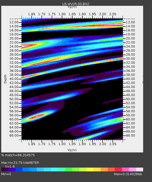
| Estimated Moho Depth: |
23.75 km |
| Estimated Crust Vp/Vs: |
1.60 |
| Assumed Crust Vp: |
6.279 km/s |
| Estimated Crust Vs: |
3.924 km/s |
| Estimated Crust Poisson's Ratio: |
0.18 |
|
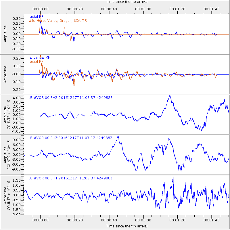
| Radial Match: |
96.204575 % |
| Radial Bump: |
400 |
| Transverse Match: |
69.32505 % |
| Transverse Bump: |
400 |
| SOD ConfigId: |
1894071 |
| Insert Time: |
2016-12-31 10:54:07.085 +0000 |
| GWidth: |
2.5 |
| Max Bumps: |
400 |
| Tol: |
0.001 |
|
Signal To Noise
| Channel | StoN | STA | LTA |
| US:WVOR:00:BHZ:20161217T11:03:37.424988Z | 6.7614694 | 1.4251908E-6 | 2.1078122E-7 |
| US:WVOR:00:BH1:20161217T11:03:37.424988Z | 0.3985498 | 1.4062198E-7 | 3.5283415E-7 |
| US:WVOR:00:BH2:20161217T11:03:37.424988Z | 1.1993631 | 4.5521594E-7 | 3.7954806E-7 |
| Arrivals |
| Ps | 2.3 SECOND |
| PpPs | 9.6 SECOND |
| PsPs/PpSs | 12 SECOND |


