You are here: Home > Network List > CI - Caltech Regional Seismic Network Stations List
> Station MPP McPhearson Peak > Earthquake Result Viewer
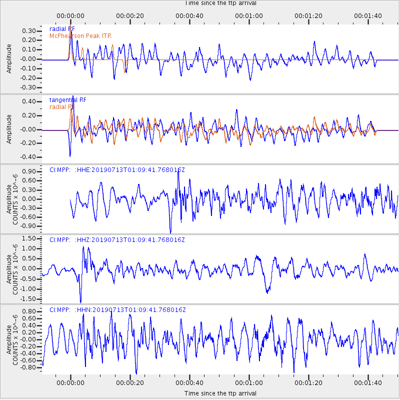
MPP McPhearson Peak - Earthquake Result Viewer
*The percent match for this event was below the threshold and hence no stack was calculated.
| Earthquake location: |
Northwest Of Ryukyu Islands |
| Earthquake latitude/longitude: |
29.4/128.2 |
| Earthquake time(UTC): |
2019/07/13 (194) 00:57:44 GMT |
| Earthquake Depth: |
251 km |
| Earthquake Magnitude: |
6.1 Mww |
| Earthquake Catalog/Contributor: |
NEIC PDE/us |
|
| Network: |
CI Caltech Regional Seismic Network |
| Station: |
MPP McPhearson Peak |
| Lat/Lon: |
34.89 N/119.81 W |
| Elevation: |
1739 m |
|
| Distance: |
89.5 deg |
| Az: |
49.646 deg |
| Baz: |
305.974 deg |
| Ray Param: |
$rayparam |
*The percent match for this event was below the threshold and hence was not used in the summary stack. |
|
| Radial Match: |
51.83606 % |
| Radial Bump: |
400 |
| Transverse Match: |
65.171104 % |
| Transverse Bump: |
400 |
| SOD ConfigId: |
19053131 |
| Insert Time: |
2019-07-27 01:01:48.890 +0000 |
| GWidth: |
2.5 |
| Max Bumps: |
400 |
| Tol: |
0.001 |
|
Signal To Noise
| Channel | StoN | STA | LTA |
| CI:MPP: :HHZ:20190713T01:09:41.768016Z | 3.2764091 | 5.9431034E-7 | 1.8139075E-7 |
| CI:MPP: :HHN:20190713T01:09:41.768016Z | 1.4099379 | 3.2725617E-7 | 2.321068E-7 |
| CI:MPP: :HHE:20190713T01:09:41.768016Z | 1.2775513 | 3.6543344E-7 | 2.8604208E-7 |
| Arrivals |
| Ps | |
| PpPs | |
| PsPs/PpSs | |


