You are here: Home > Network List > TA - USArray Transportable Network (new EarthScope stations) Stations List
> Station K09A Rome, OR, USA > Earthquake Result Viewer
K09A Rome, OR, USA - Earthquake Result Viewer
| Earthquake location: |
Northern Mid-Atlantic Ridge |
| Earthquake latitude/longitude: |
52.4/-31.8 |
| Earthquake time(UTC): |
2007/05/23 (143) 04:41:46 GMT |
| Earthquake Depth: |
10 km |
| Earthquake Magnitude: |
5.6 MS, 5.4 MB, 5.7 MW, 5.6 MW |
| Earthquake Catalog/Contributor: |
WHDF/NEIC |
|
| Network: |
TA USArray Transportable Network (new EarthScope stations) |
| Station: |
K09A Rome, OR, USA |
| Lat/Lon: |
42.70 N/117.73 W |
| Elevation: |
1176 m |
|
| Distance: |
55.5 deg |
| Az: |
296.894 deg |
| Baz: |
47.908 deg |
| Ray Param: |
0.06472968 |
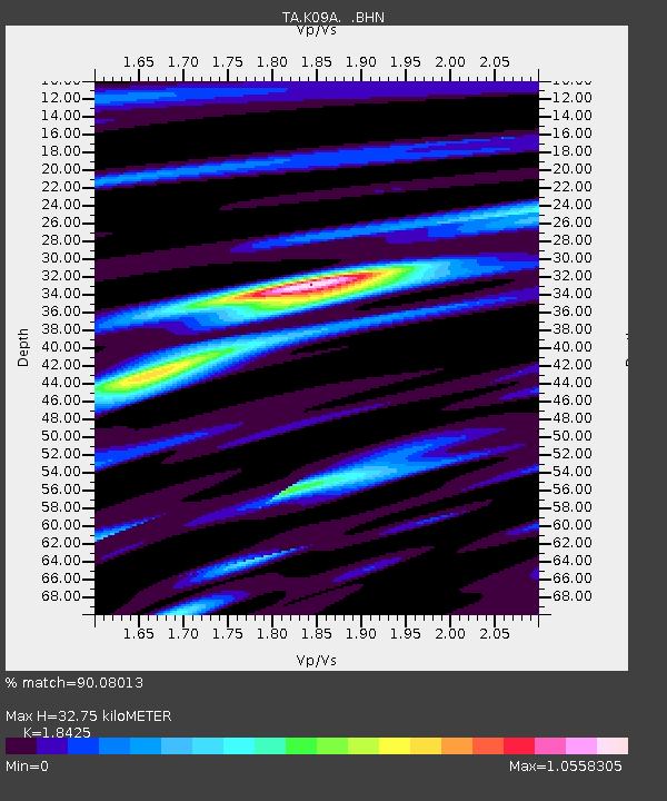
| Estimated Moho Depth: |
32.75 km |
| Estimated Crust Vp/Vs: |
1.84 |
| Assumed Crust Vp: |
6.291 km/s |
| Estimated Crust Vs: |
3.415 km/s |
| Estimated Crust Poisson's Ratio: |
0.29 |
|
| Radial Match: |
90.08013 % |
| Radial Bump: |
332 |
| Transverse Match: |
73.63501 % |
| Transverse Bump: |
400 |
| SOD ConfigId: |
2564 |
| Insert Time: |
2010-03-07 01:39:13.668 +0000 |
| GWidth: |
2.5 |
| Max Bumps: |
400 |
| Tol: |
0.001 |
|
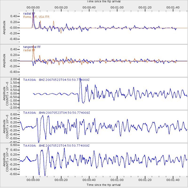
Signal To Noise
| Channel | StoN | STA | LTA |
| TA:K09A: :BHN:20070523T04:50:50.774009Z | 3.5156834 | 3.6419235E-7 | 1.03590764E-7 |
| TA:K09A: :BHE:20070523T04:50:50.774009Z | 3.9720294 | 2.2959397E-7 | 5.7802684E-8 |
| TA:K09A: :BHZ:20070523T04:50:50.774009Z | 12.178439 | 8.865088E-7 | 7.27933E-8 |
| Arrivals |
| Ps | 4.6 SECOND |
| PpPs | 14 SECOND |
| PsPs/PpSs | 19 SECOND |


