You are here: Home > Network List > UU - University of Utah Regional Network Stations List
> Station FORU South Mineral Mountains, UT, USA > Earthquake Result Viewer
FORU South Mineral Mountains, UT, USA - Earthquake Result Viewer
| Earthquake location: |
New Ireland Region, P.N.G. |
| Earthquake latitude/longitude: |
-4.5/153.6 |
| Earthquake time(UTC): |
2016/12/17 (352) 10:51:11 GMT |
| Earthquake Depth: |
73 km |
| Earthquake Magnitude: |
8.0 Mi |
| Earthquake Catalog/Contributor: |
NEIC PDE/pt |
|
| Network: |
UU University of Utah Regional Network |
| Station: |
FORU South Mineral Mountains, UT, USA |
| Lat/Lon: |
38.46 N/112.86 W |
| Elevation: |
1840 m |
|
| Distance: |
95.5 deg |
| Az: |
51.929 deg |
| Baz: |
268.706 deg |
| Ray Param: |
0.040705945 |
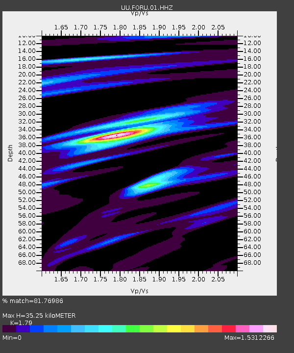
| Estimated Moho Depth: |
35.25 km |
| Estimated Crust Vp/Vs: |
1.79 |
| Assumed Crust Vp: |
6.276 km/s |
| Estimated Crust Vs: |
3.506 km/s |
| Estimated Crust Poisson's Ratio: |
0.27 |
|
| Radial Match: |
81.76986 % |
| Radial Bump: |
400 |
| Transverse Match: |
66.90741 % |
| Transverse Bump: |
400 |
| SOD ConfigId: |
1894071 |
| Insert Time: |
2016-12-31 10:54:18.000 +0000 |
| GWidth: |
2.5 |
| Max Bumps: |
400 |
| Tol: |
0.001 |
|

Signal To Noise
| Channel | StoN | STA | LTA |
| UU:FORU:01:HHZ:20161217T11:03:56.575012Z | 2.1635337 | 2.484739E-8 | 1.1484633E-8 |
| UU:FORU:01:HHN:20161217T11:03:56.575012Z | 1.5291975 | 2.3448461E-8 | 1.5333836E-8 |
| UU:FORU:01:HHE:20161217T11:03:56.575012Z | 5.002367 | 8.564491E-8 | 1.7120879E-8 |
| Arrivals |
| Ps | 4.5 SECOND |
| PpPs | 15 SECOND |
| PsPs/PpSs | 20 SECOND |


