You are here: Home > Network List > TA - USArray Transportable Network (new EarthScope stations) Stations List
> Station K09A Rome, OR, USA > Earthquake Result Viewer
K09A Rome, OR, USA - Earthquake Result Viewer
| Earthquake location: |
North Atlantic Ocean |
| Earthquake latitude/longitude: |
53.7/-35.4 |
| Earthquake time(UTC): |
2006/11/29 (333) 15:38:44 GMT |
| Earthquake Depth: |
10 km |
| Earthquake Magnitude: |
5.6 MB, 5.3 MS, 5.6 MW, 5.6 MW |
| Earthquake Catalog/Contributor: |
WHDF/NEIC |
|
| Network: |
TA USArray Transportable Network (new EarthScope stations) |
| Station: |
K09A Rome, OR, USA |
| Lat/Lon: |
42.70 N/117.73 W |
| Elevation: |
1176 m |
|
| Distance: |
53.0 deg |
| Az: |
293.773 deg |
| Baz: |
47.512 deg |
| Ray Param: |
0.066418536 |
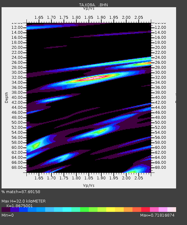
| Estimated Moho Depth: |
32.0 km |
| Estimated Crust Vp/Vs: |
1.87 |
| Assumed Crust Vp: |
6.291 km/s |
| Estimated Crust Vs: |
3.369 km/s |
| Estimated Crust Poisson's Ratio: |
0.30 |
|
| Radial Match: |
87.69158 % |
| Radial Bump: |
400 |
| Transverse Match: |
75.24724 % |
| Transverse Bump: |
400 |
| SOD ConfigId: |
2564 |
| Insert Time: |
2010-03-07 01:39:30.125 +0000 |
| GWidth: |
2.5 |
| Max Bumps: |
400 |
| Tol: |
0.001 |
|

Signal To Noise
| Channel | StoN | STA | LTA |
| TA:K09A: :BHN:20061129T15:47:30.025024Z | 3.0633626 | 3.5448727E-7 | 1.1571835E-7 |
| TA:K09A: :BHE:20061129T15:47:30.025024Z | 1.4143572 | 2.0276848E-7 | 1.4336442E-7 |
| TA:K09A: :BHZ:20061129T15:47:30.025024Z | 5.786725 | 9.0058296E-7 | 1.5562912E-7 |
| Arrivals |
| Ps | 4.6 SECOND |
| PpPs | 14 SECOND |
| PsPs/PpSs | 19 SECOND |


