You are here: Home > Network List > CN - Canadian National Seismograph Network Stations List
> Station NLLB Nanaimo Lost Lake, BC, CA > Earthquake Result Viewer
NLLB Nanaimo Lost Lake, BC, CA - Earthquake Result Viewer
| Earthquake location: |
Northwest Of Ryukyu Islands |
| Earthquake latitude/longitude: |
29.4/128.2 |
| Earthquake time(UTC): |
2019/07/13 (194) 00:57:44 GMT |
| Earthquake Depth: |
251 km |
| Earthquake Magnitude: |
6.1 Mww |
| Earthquake Catalog/Contributor: |
NEIC PDE/us |
|
| Network: |
CN Canadian National Seismograph Network |
| Station: |
NLLB Nanaimo Lost Lake, BC, CA |
| Lat/Lon: |
49.23 N/123.99 W |
| Elevation: |
199 m |
|
| Distance: |
78.9 deg |
| Az: |
39.488 deg |
| Baz: |
302.131 deg |
| Ray Param: |
0.048683286 |
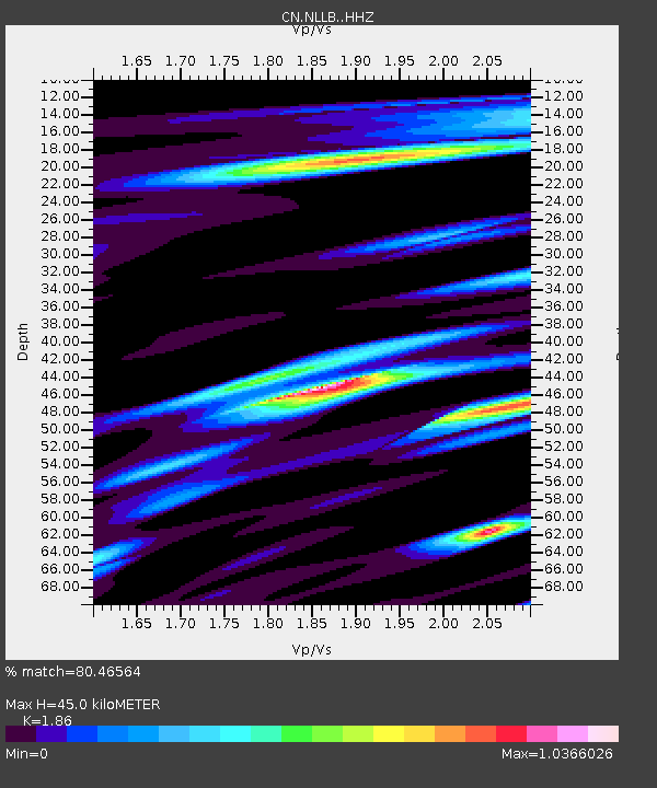
| Estimated Moho Depth: |
45.0 km |
| Estimated Crust Vp/Vs: |
1.86 |
| Assumed Crust Vp: |
6.566 km/s |
| Estimated Crust Vs: |
3.53 km/s |
| Estimated Crust Poisson's Ratio: |
0.30 |
|
| Radial Match: |
80.46564 % |
| Radial Bump: |
400 |
| Transverse Match: |
76.73983 % |
| Transverse Bump: |
400 |
| SOD ConfigId: |
19053131 |
| Insert Time: |
2019-07-27 01:02:30.625 +0000 |
| GWidth: |
2.5 |
| Max Bumps: |
400 |
| Tol: |
0.001 |
|

Signal To Noise
| Channel | StoN | STA | LTA |
| CN:NLLB: :HHZ:20190713T01:08:48.669994Z | 6.7633014 | 7.852618E-7 | 1.1610629E-7 |
| CN:NLLB: :HHN:20190713T01:08:48.669994Z | 4.507417 | 2.5827248E-7 | 5.7299438E-8 |
| CN:NLLB: :HHE:20190713T01:08:48.669994Z | 1.9932029 | 1.9268384E-7 | 9.667046E-8 |
| Arrivals |
| Ps | 6.1 SECOND |
| PpPs | 19 SECOND |
| PsPs/PpSs | 25 SECOND |


