You are here: Home > Network List > TA - USArray Transportable Network (new EarthScope stations) Stations List
> Station K09A Rome, OR, USA > Earthquake Result Viewer
K09A Rome, OR, USA - Earthquake Result Viewer
| Earthquake location: |
Gulf Of Mexico |
| Earthquake latitude/longitude: |
26.3/-86.6 |
| Earthquake time(UTC): |
2006/09/10 (253) 14:56:08 GMT |
| Earthquake Depth: |
14 km |
| Earthquake Magnitude: |
5.9 MB, 5.5 MS, 5.8 MW, 5.8 MW |
| Earthquake Catalog/Contributor: |
WHDF/NEIC |
|
| Network: |
TA USArray Transportable Network (new EarthScope stations) |
| Station: |
K09A Rome, OR, USA |
| Lat/Lon: |
42.70 N/117.73 W |
| Elevation: |
1176 m |
|
| Distance: |
30.2 deg |
| Az: |
310.738 deg |
| Baz: |
112.706 deg |
| Ray Param: |
0.07939309 |
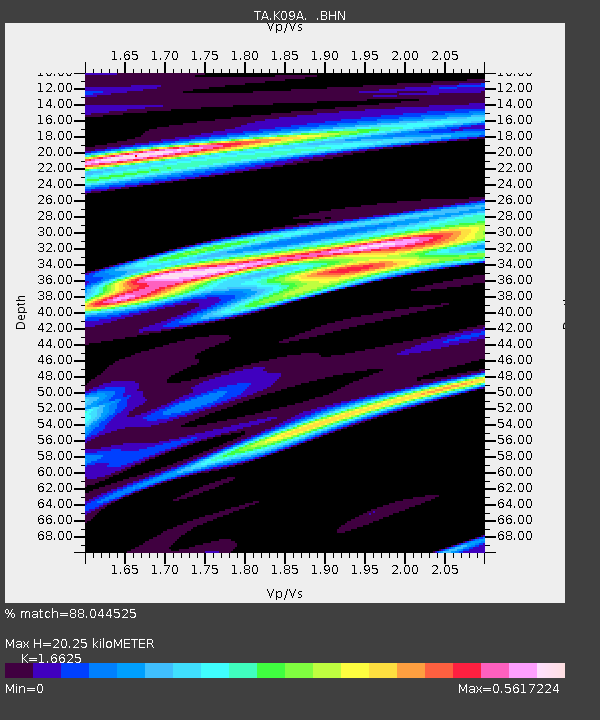
| Estimated Moho Depth: |
20.25 km |
| Estimated Crust Vp/Vs: |
1.66 |
| Assumed Crust Vp: |
6.291 km/s |
| Estimated Crust Vs: |
3.784 km/s |
| Estimated Crust Poisson's Ratio: |
0.22 |
|
| Radial Match: |
88.044525 % |
| Radial Bump: |
282 |
| Transverse Match: |
70.45787 % |
| Transverse Bump: |
400 |
| SOD ConfigId: |
2665 |
| Insert Time: |
2010-03-07 01:39:57.309 +0000 |
| GWidth: |
2.5 |
| Max Bumps: |
400 |
| Tol: |
0.001 |
|

Signal To Noise
| Channel | StoN | STA | LTA |
| TA:K09A: :BHN:20060910T15:01:47.248013Z | 1.8325992 | 1.9375086E-7 | 1.05724624E-7 |
| TA:K09A: :BHE:20060910T15:01:47.248013Z | 8.618901 | 7.137531E-7 | 8.2812534E-8 |
| TA:K09A: :BHZ:20060910T15:01:47.248013Z | 25.170086 | 1.6223404E-6 | 6.44551E-8 |
| Arrivals |
| Ps | 2.3 SECOND |
| PpPs | 7.9 SECOND |
| PsPs/PpSs | 10 SECOND |


