You are here: Home > Network List > TA - USArray Transportable Network (new EarthScope stations) Stations List
> Station G08A Pilot Rock, OR, USA > Earthquake Result Viewer
G08A Pilot Rock, OR, USA - Earthquake Result Viewer
| Earthquake location: |
East Of Kuril Islands |
| Earthquake latitude/longitude: |
46.0/154.2 |
| Earthquake time(UTC): |
2007/10/25 (298) 13:50:02 GMT |
| Earthquake Depth: |
10 km |
| Earthquake Magnitude: |
6.0 MB, 5.7 MS, 6.1 MW, 5.9 MW |
| Earthquake Catalog/Contributor: |
WHDF/NEIC |
|
| Network: |
TA USArray Transportable Network (new EarthScope stations) |
| Station: |
G08A Pilot Rock, OR, USA |
| Lat/Lon: |
45.29 N/118.96 W |
| Elevation: |
1318 m |
|
| Distance: |
57.6 deg |
| Az: |
56.556 deg |
| Baz: |
304.529 deg |
| Ray Param: |
0.06336503 |
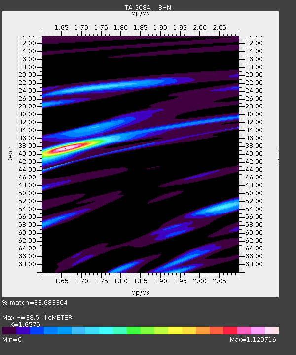
| Estimated Moho Depth: |
38.5 km |
| Estimated Crust Vp/Vs: |
1.66 |
| Assumed Crust Vp: |
6.571 km/s |
| Estimated Crust Vs: |
3.964 km/s |
| Estimated Crust Poisson's Ratio: |
0.21 |
|
| Radial Match: |
83.683304 % |
| Radial Bump: |
384 |
| Transverse Match: |
67.221664 % |
| Transverse Bump: |
400 |
| SOD ConfigId: |
2564 |
| Insert Time: |
2010-03-07 01:40:25.286 +0000 |
| GWidth: |
2.5 |
| Max Bumps: |
400 |
| Tol: |
0.001 |
|

Signal To Noise
| Channel | StoN | STA | LTA |
| TA:G08A: :BHN:20071025T13:59:21.750005Z | 3.546718 | 3.0486078E-7 | 8.595575E-8 |
| TA:G08A: :BHE:20071025T13:59:21.750005Z | 1.655044 | 1.8209816E-7 | 1.10026185E-7 |
| TA:G08A: :BHZ:20071025T13:59:21.750005Z | 2.271466 | 3.021801E-7 | 1.3303307E-7 |
| Arrivals |
| Ps | 4.1 SECOND |
| PpPs | 15 SECOND |
| PsPs/PpSs | 19 SECOND |


